


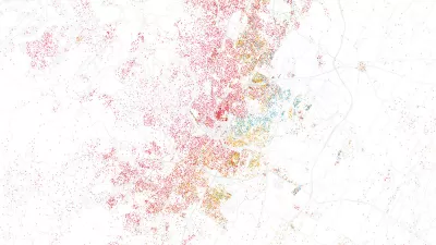
Geographer Duncan Smith mapped the predicted trajectory of worldwide urban growth from 1950 through 2030. Concentric circles of different shades show where and when growth was (or will be) the most dramatic.
CityLab writer Tanvi Misra has high praise for an interactive map of worldwide urban growth created by urban geographer Duncan Smith.
Misra writes, "In its 2014 World Urbanization Prospects report, the UN tracked the populations of major cities from 1950 to 2014, then predicted how these populations would grow (or shrink) up to the year 2030. Using these data, Smith represented each city on his map with a dark blue core, the size of which is proportional to the city's 1950 population. The concentric circles around that core, in lighter blue, vary according to the city's population in 1990, 2015, and 2030."
The result, which is quite pretty to look at, also highlights urbanization's dramatic shift from West to East. Urban China and India, as well as several African cities, stand out as new powerhouses come 2030.
FULL STORY: Mapping 65 Years of Explosive Urban Growth


As Temperatures Increase, Maps Show Sea-Level Rise Will Devastate Cities
Data visualizations illustrate the catastrophic consequences of single-digit global temperature increases.
Visualizing the Growth of the World's Urban Population
An interactive visualization recently released by Unicef presents a startling picture of the world's urban population growth from 1950 to 2050. Mark Wilson deconstructs its implications.
Esri App Makes Data Visualization Easy
A wealth of pre-authored policy maps lets users access data to explore public policy issues.

Planetizen Federal Action Tracker
A weekly monitor of how Trump’s orders and actions are impacting planners and planning in America.

Congressman Proposes Bill to Rename DC Metro “Trump Train”
The Make Autorail Great Again Act would withhold federal funding to the system until the Washington Metropolitan Area Transit Authority (WMATA), rebrands as the Washington Metropolitan Authority for Greater Access (WMAGA).

The Simple Legislative Tool Transforming Vacant Downtowns
In California, Michigan and Georgia, an easy win is bringing dollars — and delight — back to city centers.

The States Losing Rural Delivery Rooms at an Alarming Pace
In some states, as few as 9% of rural hospitals still deliver babies. As a result, rising pre-term births, no adequate pre-term care and "harrowing" close calls are a growing reality.

The Small South Asian Republic Going all in on EVs
Thanks to one simple policy change less than five years ago, 65% of new cars in this Himalayan country are now electric.

DC Backpedals on Bike Lane Protection, Swaps Barriers for Paint
Citing aesthetic concerns, the city is removing the concrete barriers and flexposts that once separated Arizona Avenue cyclists from motor vehicles.
Urban Design for Planners 1: Software Tools
This six-course series explores essential urban design concepts using open source software and equips planners with the tools they need to participate fully in the urban design process.
Planning for Universal Design
Learn the tools for implementing Universal Design in planning regulations.
Smith Gee Studio
City of Charlotte
City of Camden Redevelopment Agency
City of Astoria
Transportation Research & Education Center (TREC) at Portland State University
US High Speed Rail Association
City of Camden Redevelopment Agency
Municipality of Princeton (NJ)