


A new online mapping project called American Panorama earned rave reviews this week from CityLab and Gizmodo.
Writing for CityLab, Laura Bliss describes the ambition of the American Panorama project, as conceived by a collaboration between the University of Richmond's Digital Scholarship Lab and the cartography firm Stamen. Though the maps are specifically designed to look contemporary, according to Bliss, " these are not the simple animated maps or hover-over statistical visualizations to which Internet trawlers are by now so accustomed. The Panorama’s plates are dense, like entire textbook chapters turned interactive tools."
Bliss goes on to focus on two of the project's maps (the project's website promises more in the future): "Foreign-Born Population: A Nation of Overlapping Diasporas" and "Forced Migration of Enslaved People."
Writing for Gizmodo, Alissa Walker also focused on the former of those two maps in addition to a map of overland trails showing how pioneers settled the American West. Walker also provides this effusive review: "This is data storytelling at its very finest and I’m really looking forward to seeing what other topics American Panorama covers."
FULL STORY: A Historical Atlas of America, Built for the 21st Century

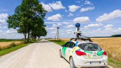
How Digital Mapping Can Reinforce Inequity
Digital mapping tools like Google Street View often obscure the realities of cities and concentrate their resources in the wealthiest countries, effectively ‘erasing’ some places from the global map.

New Interactive Mapping Tool Tracks all of NYC's Infrastructure Projects, Housing Permits, and City Facilities
The New York Department of City Planning has taken its open data practices to a new level with the launch of the Capital Planning Explorer.

Smart Growth Loves Heatmaps
Smart growth can provide many important benefits that are easy to see using informative and beautiful heatmaps—our complex world as viewed by all-knowing gods.

Maui's Vacation Rental Debate Turns Ugly
Verbal attacks, misinformation campaigns and fistfights plague a high-stakes debate to convert thousands of vacation rentals into long-term housing.

Planetizen Federal Action Tracker
A weekly monitor of how Trump’s orders and actions are impacting planners and planning in America.

In Urban Planning, AI Prompting Could be the New Design Thinking
Creativity has long been key to great urban design. What if we see AI as our new creative partner?

Florida Seniors Face Rising Homelessness Risk
High housing costs are pushing more seniors, many of them on a fixed income, into homelessness.

Massachusetts Budget Helps Close MBTA Budget Gap
The budget signed by Gov. Maura Healey includes $470 million in MBTA funding for the next fiscal year.

Milwaukee Launches Vision Zero Plan
Seven years after the city signed its Complete Streets Policy, the city is doubling down on its efforts to eliminate traffic deaths.
Urban Design for Planners 1: Software Tools
This six-course series explores essential urban design concepts using open source software and equips planners with the tools they need to participate fully in the urban design process.
Planning for Universal Design
Learn the tools for implementing Universal Design in planning regulations.
Gallatin County Department of Planning & Community Development
Heyer Gruel & Associates PA
JM Goldson LLC
City of Camden Redevelopment Agency
City of Astoria
Transportation Research & Education Center (TREC) at Portland State University
Jefferson Parish Government
Camden Redevelopment Agency
City of Claremont