


Created with input from historian Mark Footer, this tool overlays street views of modern Hong Kong with historical photos from the colonial era through the 20th century.
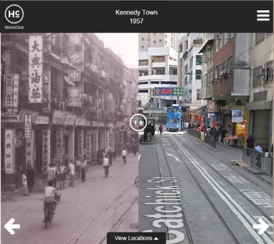
Here's an interesting urban visualization tool, this time featuring an Asian city. Historic Hong Kong interposes old photographs of notable locations onto how the streets look today using Google Street View. Users can hover over the historical photograph to switch between views.
According to outreach specialist Yolanda del Peso, the tool is optimized for mobile users: "If you are looking at it on mobile, or you shrink your browser down to mobile size, you can utilise a fader type functionality where you can literally swipe across to see the street now vs. 100 years ago - giving you what is almost a split screen view."
Planetizen has covered similar tools in the past, including an extensive effort to map wild Manhattan circa 1600.
FULL STORY: Historic Hong Kong

The Look and Feel of 'Inherently Urban'
Greek orators, current solution-based efforts, and 25 photographs remind us of the central role of human opportunity in the urban environment.
Interpreting the 'Timeless and Time-Bound' in Cities
In his latest essay on interpretation of the urban environment, Chuck Wolfe suggests that if we take away context clues cities become matrices -- with blank cells to complete -- where each of us personalizes how space meets time.
Hong Kong Cab Hailing App Folds — and Uber Takes Over
HKTaxi launched a year before Uber came to town. Now, it’s shutting down. Lawmakers worry a monopoly looms.

Rethinking Redlining
For decades we have blamed 100-year-old maps for the patterns of spatial racial inequity that persist in American cities today. An esteemed researcher says: we’ve got it all wrong.

Planetizen Federal Action Tracker
A weekly monitor of how Trump’s orders and actions are impacting planners and planning in America.

California High-Speed Rail's Plan to Right Itself
The railroad's new CEO thinks he can get the project back on track. The stars will need to align this summer.

Savannah Reduces Speed Limits on Almost 100 City Streets
The historic Georgia city is lowering speed limits in an effort to reduce road fatalities.

A Park Reborn: Resilience and Renewal in Fire-Stricken Altadena
Rebuilt in just two months after the devastating Eaton Fire, Loma Alta Park now stands as a symbol of community resilience and renewal, even as some residents hope recovery efforts will continue to support housing stability and long-term equity.

Spain Moves to Ban 66,000 Airbnbs
The national government is requiring the short-term rental operator to remove thousands of illegal listings from its site as part of an effort to stem a growing housing crisis.
Urban Design for Planners 1: Software Tools
This six-course series explores essential urban design concepts using open source software and equips planners with the tools they need to participate fully in the urban design process.
Planning for Universal Design
Learn the tools for implementing Universal Design in planning regulations.
City of Clovis
City of Moorpark
City of Camden Redevelopment Agency
City of Astoria
Transportation Research & Education Center (TREC) at Portland State University
Regional Transportation Commission of Southern Nevada
Toledo-Lucas County Plan Commissions