


A 1.5-acre park in Cleveland should be ready in time for the 2016 Republican National Convention. The small park is just the first step, however, toward a much grander vision for a corner of Cleveland with deep connections to the city's past.
The first step toward a grand vision for the Canal Basin Park is underway in Cleveland. Steven Litt reports about the current planning for a park project on 1.5 acres of what will eventually become 20 acres of ambitiously designed park space.
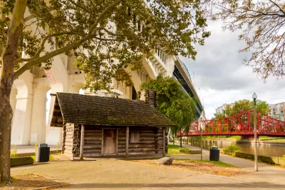
The 1.5-acre park currently underway with planning will be "located near the intersection of Center Street and Merwin Avenue on the east bank of the Flats," reports Litt. For now, Cleveland Metroparks will use $300,000 in tax increment financing to "install grass, walking paths and trees on the 1.5-acre parcel, connecting Columbus Road and Center Street down to Heritage Park on Cuyahoga River." A parking lot will also be removed.
Litt notes that the park's location "may be obscure geography to some Clevelanders, but it wasn't in the past and won't be in the future." And the future, signified by the plans for Canal Basin Park, could be on its way much faster now. The city's Planning Commission scheduled to review the park's framework plan later in November.
The name Canal Basin indicates the site's importance in Cleveland history. As Litt notes, the "larger park will mark the northern terminus of the 110-mile Towpath Trail, and focus fresh attention on the original northern end of the Ohio & Erie Canal, completed in 1832."
FULL STORY: Metroparks plans "greening" for 1.5-acres of the future 20-acre Canal Basin Park (photos)

Not a Walk in the Park: What It Really Takes to Build Green Spaces
Park creation can take decades of perseverance to overcome financial, regulatory, and social hurdles, but the end result for the local community is more than worth it.
Envisioning a New Park in East Los Angeles
Los Angeles County is working towards transforming underutilized land into a vibrant pocket park in the City Terrace neighborhood of East LA.

Using Cellphone and Fitness App Data for Park Planning
Data from smartphone apps and fitness trackers are helping planners to better understand park usage patterns and plan for new and improved parks.

Planetizen Federal Action Tracker
A weekly monitor of how Trump’s orders and actions are impacting planners and planning in America.

Restaurant Patios Were a Pandemic Win — Why Were They so Hard to Keep?
Social distancing requirements and changes in travel patterns prompted cities to pilot new uses for street and sidewalk space. Then it got complicated.

Map: Where Senate Republicans Want to Sell Your Public Lands
For public land advocates, the Senate Republicans’ proposal to sell millions of acres of public land in the West is “the biggest fight of their careers.”

Maui's Vacation Rental Debate Turns Ugly
Verbal attacks, misinformation campaigns and fistfights plague a high-stakes debate to convert thousands of vacation rentals into long-term housing.

San Francisco Suspends Traffic Calming Amidst Record Deaths
Citing “a challenging fiscal landscape,” the city will cease the program on the heels of 42 traffic deaths, including 24 pedestrians.

California Homeless Arrests, Citations Spike After Ruling
An investigation reveals that anti-homeless actions increased up to 500% after Grants Pass v. Johnson — even in cities claiming no policy change.
Urban Design for Planners 1: Software Tools
This six-course series explores essential urban design concepts using open source software and equips planners with the tools they need to participate fully in the urban design process.
Planning for Universal Design
Learn the tools for implementing Universal Design in planning regulations.
Heyer Gruel & Associates PA
JM Goldson LLC
Custer County Colorado
City of Camden Redevelopment Agency
City of Astoria
Transportation Research & Education Center (TREC) at Portland State University
Camden Redevelopment Agency
City of Claremont
Municipality of Princeton (NJ)