


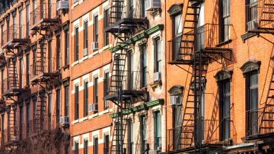
The neighborhood of Chelsea in Manhattan, location of the High Line and one of the hottest real estate markets in the city, provides a case study of the wealth gap, with each side living in close proximity.
"Census and city figures show that the average household income in Chelsea, about $140,000, is almost five times the average for households in public housing in the area," according to Mireya Navarro. "The neighborhood now ranks among those in the city with the greatest income inequality, according to the Furman Center for Real Estate and Urban Policy at New York University, as the share of households in the highest income brackets — over $250,000 — has grown."
The article notes the ongoing tension behind two housing initiatives moving forward under the direction of Mayor Bill de Blasio: the upzoning of East New York and a proposal to build new housing on properties controlled by the New York City Housing Authority. Both of those proposals have sparked concerns among residents that they will be displaced by rising costs connected with new developments. Navarri cites Chelsea's example for some perspective on the current controversy affecting those parts of the city.
"In long-gentrified Chelsea, the worst fears have yet to come true. The housing projects — Fulton Houses (between 16th and 19th Streets and Ninth and 10th Avenues) and the neighboring Elliot and Chelsea Houses (in the mid-20s) — with about 2,000 apartments combined, are still there, as they have been since the 1940s (Elliot) and ’60s (Fulton and Chelsea). The brick buildings have deteriorated, however, under the weight of time and as the Housing Authority’s maintenance budget has fallen short, although city officials say they remain committed to preserving public housing."
The article goes onto describe how the dichotomy of income levels impacts the people on the low end of the spectrum—citing some examples of how policy neglects the block-by-block discrepancies of neighborhoods like Chelsea when data is only considered at the ZIP Code level.
FULL STORY: In Chelsea, a Great Wealth Divide

One Fourth of East Harlem Housing Set to Lose Affordability
The area could lose up to 500 units of affordable housing every year for the next 30 years if the city doesn't extend existing protections.
Explained: East New York's Big Zoning Changes
Some residents of East New York argue that mandatory inclusionary zoning and other changes proposed for the neighborhood will only help displace low-income residents.
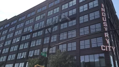
‘Emergent City’ Documentary Highlights Rare Anti-Gentrification Victory
The film charts the saga of a Brooklyn site called Industry City.

Montreal Mall to Become 6,000 Housing Units
Place Versailles will be transformed into a mixed-use complex over the next 25 years.

Planetizen Federal Action Tracker
A weekly monitor of how Trump’s orders and actions are impacting planners and planning in America.

DARTSpace Platform Streamlines Dallas TOD Application Process
The Dallas transit agency hopes a shorter permitting timeline will boost transit-oriented development around rail stations.

Interactive Map Reveals America's “Shade Deserts”
Launched by UCLA and American Forests to combat heat-related deaths, the tool maps the shade infrastructure for over 360 U.S. cities.

Bicycles and Books — In Sacramento, Libraries Now Offer Both
Adult library card holders can check out e-bikes and e-trikes for up to one week.

Colorado Landfills Emit as Much Pollution as 1M Cars
Landfills are the third-largest source of methane pollution in Colorado, after agriculture and fossil fuel extraction.
Urban Design for Planners 1: Software Tools
This six-course series explores essential urban design concepts using open source software and equips planners with the tools they need to participate fully in the urban design process.
Planning for Universal Design
Learn the tools for implementing Universal Design in planning regulations.
City of Mt Shasta
City of Camden Redevelopment Agency
City of Astoria
Transportation Research & Education Center (TREC) at Portland State University
US High Speed Rail Association
City of Camden Redevelopment Agency
Municipality of Princeton (NJ)