


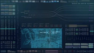
With so many potential sources of data with which to analyze traffic behaviors and real-time conditions, University of Toronto engineers have created an online portal that could one day help drive a system populated with autonomous cars.
Tyler Irving explains the Connected Vehicles and Smart Transportation (CVST) portal, a new tool that "aims to bring harmony to how we monitor and manage traffic by integrating existing traffic monitoring data, using new technologies to address the gaps and generating insights that can inform decision making."
The portal, overseen by University of Toronto Engineering Professor Alberto Leon-Garcia with support from the University of Toronto Transportation Research Institute, includes a high-definition video feed produced by drones among data collected from "smart phones (Google Maps, Twitter), TTC buses, BIXI bicycles, border crossings and much more." Irving explains more about how the portal makes sense of all that data:
"Although it pulls all these data sources together, CVST is more than simply an aggregator of new and existing information. It also incorporates an analytics layer, which uses machine learning and other techniques to translate data into useful information. Crucially, these outputs are made available via an open application program interface (API). This allows anyone from curious citizens to city planners to app developers to leverage the system in order to meet their own needs."
FULL STORY: An open data platform for improving Toronto transportation


A More Complete Picture of the 'Smart City' Plans in Toronto
The game changing redevelopment proposed by Sidewalk Labs for the Toronto waterfront district of Quayside took new shape recently after the company presented an updated draft of its plan.
How Data-Driven Research Is Shaping Sustainable Urban Development
Explore how data-driven research is revolutionizing sustainable urban development, creating smarter, greener, and more resilient cities for the future.
Tech Trends for Cities and States
Smart cities technology is well behind schedule, but the technology industry hasn’t given up on new digital solutions, self-driving cars, curb management, and AI-powered systems.

Maui's Vacation Rental Debate Turns Ugly
Verbal attacks, misinformation campaigns and fistfights plague a high-stakes debate to convert thousands of vacation rentals into long-term housing.

Planetizen Federal Action Tracker
A weekly monitor of how Trump’s orders and actions are impacting planners and planning in America.

In Urban Planning, AI Prompting Could be the New Design Thinking
Creativity has long been key to great urban design. What if we see AI as our new creative partner?

King County Supportive Housing Program Offers Hope for Unhoused Residents
The county is taking a ‘Housing First’ approach that prioritizes getting people into housing, then offering wraparound supportive services.

Researchers Use AI to Get Clearer Picture of US Housing
Analysts are using artificial intelligence to supercharge their research by allowing them to comb through data faster. Though these AI tools can be error prone, they save time and housing researchers are optimistic about the future.

Making Shared Micromobility More Inclusive
Cities and shared mobility system operators can do more to include people with disabilities in planning and operations, per a new report.
Urban Design for Planners 1: Software Tools
This six-course series explores essential urban design concepts using open source software and equips planners with the tools they need to participate fully in the urban design process.
Planning for Universal Design
Learn the tools for implementing Universal Design in planning regulations.
planning NEXT
Appalachian Highlands Housing Partners
Mpact (founded as Rail~Volution)
City of Camden Redevelopment Agency
City of Astoria
City of Portland
City of Laramie