


Not all transit maps are created equal. The new Portland TriMet map, for instance, does a much better job of illustrating the usefulness of its high-frequency network.
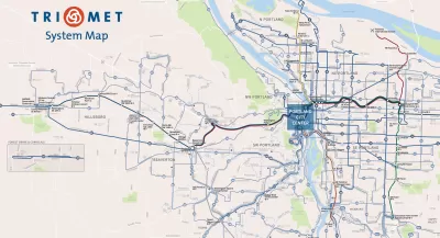
Evan Landman writes a post explain the importance of quality mapping to illustrate the frequent service routes in a bus system. To do so, Landman focuses on the city of Portland:
"Portland's agency TriMet has traditionally been a best practice example here, given their extensive Frequent Network branding down to the individual stop level, but curiously, their system map has not embraced this idea so wholeheartedly. Today, TriMet's new system map [pdf] changes that, introducing a cleaner, more readable map, which does a much better job of highlighting the agency's premier bus services."
The post goes on to describe how the design details have changed between the old map and the new. To summarize the key success of the new map: "This is a map that truly focuses on communicating the usefulness of the transit routes. The most important factor for usefulness is frequency, which is obscured when every line on the map is the same color, or a different color, or colored by a less important attribute, like which corner of the city it serves. "
FULL STORY: Portland: New Transit Map Underscores Frequent Network


TriMet Ridership Grows Thanks to Realignment, Schedule Changes
The agency’s response to post-pandemic changes in travel behavior is paying off.

Portland ‘BRT Light’ Line Shows Promise
Despite not having fully dedicated bus lanes, Portland’s new ‘light’ bus rapid transit line is significantly reducing travel times.
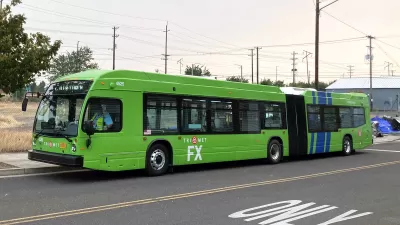
Portland ‘Frequent Express’ Bus Speeding Travel Times
TriMet’s newest line is improving service and reducing travel times for riders as ridership slowly recovers.

Maui's Vacation Rental Debate Turns Ugly
Verbal attacks, misinformation campaigns and fistfights plague a high-stakes debate to convert thousands of vacation rentals into long-term housing.

Planetizen Federal Action Tracker
A weekly monitor of how Trump’s orders and actions are impacting planners and planning in America.

In Urban Planning, AI Prompting Could be the New Design Thinking
Creativity has long been key to great urban design. What if we see AI as our new creative partner?

San Francisco Mayor Backtracks on Homelessness Goal
Mayor Dan Lurie ran on a promise to build 1,500 additional shelter beds in the city, complete with supportive services. Now, his office says they are “shifting strategy” to focus on prevention and mental health treatment.

How Trump's HUD Budget Proposal Would Harm Homelessness Response
Experts say the change to the HUD budget would make it more difficult to identify people who are homeless and connect them with services, and to prevent homelessness.

The Vast Potential of the Right-of-Way
One writer argues that the space between two building faces is the most important element of the built environment.
Urban Design for Planners 1: Software Tools
This six-course series explores essential urban design concepts using open source software and equips planners with the tools they need to participate fully in the urban design process.
Planning for Universal Design
Learn the tools for implementing Universal Design in planning regulations.
Gallatin County Department of Planning & Community Development
Heyer Gruel & Associates PA
JM Goldson LLC
Mpact (founded as Rail~Volution)
City of Camden Redevelopment Agency
City of Astoria
Jefferson Parish Government
Camden Redevelopment Agency
City of Claremont