


Sean O'Malley and Andrew Watkins, of the landscape architecture, planning, and urban design firm SWA, describe the benefits of a design process that empowers people and communities to participate.
Human- and user-centered design is changing the way companies think about how they build products and services—from intuitive thermostats that connect with smartphones to products that track and encourage fitness to more effective solutions for global development challenges. Design consultancies of all varieties are using ethnography and qualitative and quantitative research methods to create people-driven solutions. These design-thinkers are responding not just to their own hypotheses of problems and solutions. They are also observing the lifestyle, habits, and values of individuals to determine which solutions will be the most effective and most likely to be adopted. As professionals in the fields of landscape architecture, architecture, and urban planning and design seek to create projects that are beautiful, functional, and sustainable, they would be wise to scale that human-centered design model by mandating community-driven design.
When we talk about human-centered design, we are referring to a process that puts people, or end-recipients, at the center of the process. Human-centered design also develops prototypes and solutions by performing embedded qualitative and quantitative research on those same people and end-recipients. When we adapt this model to the community and city level, we are describing a process by which the community we are designing for, and its unique combination of culture, geography, and socioeconomics, becomes the center of the design process. All of our design tactics and combination of landscape, public space, amenities, and other solutions are informed directly by the needs, desires, and habits of that community. This process requires designers to be nimble and flexible enough to adapt and edit their solutions based on community feedback—integrating and engaging the community into every step of the process from pre-design research and dialogue, to getting feedback on design concepts and prototypes, to noticing how the community uses the final product and making changes accordingly. So how exactly can we begin to integrate this approach into our process?
Defining the problem
While architects and urban planners may work closely with developers, local government officials, and private contractors to get projects off the ground, at the end of the day we're creating a product—whether it be a park, a building, or an entirely new streetscape or city—that serves the residents of a community. Without observing the community's relationship to the space around them and without earning buy-in from the community, we risk creating projects that fail to serve their intended purposes.
As part of the BMW Guggenheim Lab's efforts in Mumbai, designer Neville Mars was tasked with engaging with the community to develop innovative solutions to some of the megacity's most complex urban issues. Many had suggested to Mars that traffic congestion would be one of the primary topics he’d need to look at, but once he started actually embedding himself in the community, he realized that water pollution was actually a far more immediate concern. From there, Mars and his team were able to come up with solutions that were both imaginative and strategic. In this case the solution was the Landlink Design Prototype—a rickshaw highway connecting two of the city's largest slum areas and offering residents new access to potable water. Mars then workshopped his ideas and held a symposium to refine these ideas with Mumbaikars, ranging from slum residents to government entities to private companies.
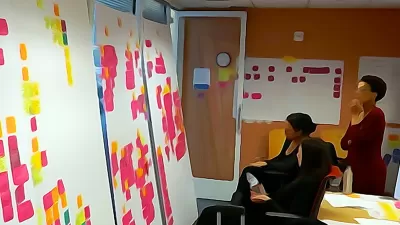
Letting the community lead the way
In most cases, landscape architects lead both the design and planning process—we use our clients' broadly stated goals as a jumping off point to find the solutions that we think would work within those parameters.
We were lucky to have the opportunity to work with a new kind of process in the city of Inglewood, California, where the residents of the community took the lead in the conception and development of a citywide greening plan—with our team taking a backseat and supporting them in articulating and achieving their goals. Many themes from this reverse planning process can be found in ideo.org's design kit, which outlines the human-centered design process step by step—from group interviews and brainstorming to co-creation and feedback sessions to designing the greening plan together with the community to cross-sector partnerships (the project was spearheaded by environmental nonprofit Tree People and local community organization Social Justice Learning Institute).
This approach has the benefit of empowering members of the community—many of whom feel alienated by a history of development projects gaining approval without consultation from the community—through an educational and inclusive process that incorporates the expertise and best practices of design and planning professionals. This can be an especially strong model in communities like Inglewood, which are desperately in need of quality planning and design but have limited city resources to implement these kinds of programs.
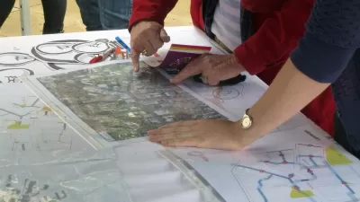
Designing for both average and exceptional users
With New York City's East River Blueway—an ambitious plan to develop a 30-block-long path and adjacent recreational and sustainable amenities along the east side of Manhattan—project organizers faced a common challenge of designing a plan that would appease as many of the constituents touched as possible. All parties involved in the planning process, including local government, nonprofit, neighborhood, and recreation groups, put in extra effort to implement another best practice in human-centered design—designing for both mainstream and extreme users. In the case of this project and many others that involve extensive public hearings and community meetings, the most vocal residents tend to show up and have their voices and ideas heard, but the more moderate members of the community tend to get left out of the process.
As one of the project's biggest champions, Assemblymember Brian Kavanagh, put it in a conversation we had with him:
"Initially we focused on making sure that we had the widest range possible of participation from community members. A lot of times plans like this come together and those people who may be particularly dependent on good public infrastructure and access to good public spaces and who may have less access to those things than others don’t tend to hear about them and don’t tend to participate. We worked to make sure that the planning sessions were representative of the community. So the tens of thousands of residents who live along the river were just as likely to be in the room as those people with planning and other backgrounds that made them professionally interested in this.
These sessions, once you got into it, had this incredible energy. People who in many cases have lived here forever, their whole lives, and you sort of felt like nobody had ever really asked them or had ever said the East River is your river, in some cases literally a stone’s throw from your home, and what would you like to see?"
To make sure that residents and community members across the planning knowledge and participation spectrum would be involved, they brought in community research and outreach consultants, in this case the Lower East Side Ecology Center, to make sure that neighbors were attending the meetings and that they understood some of the more complex landscape architecture and planning aspects of the project. The result is a plan that is highly attuned to the needs and concerns of residents of the community, that will draw visitors and tourists to a part of Manhattan that is generally overlooked, that will improve the area’s surrounding ecology, and, finally, that will provide a resilient barrier for future extreme weather patterns. That sounds like a win-win-win.
Community-centered design has the potential to create inclusive work that better serves all constituents involved. As we in the design and planning professions look for new ways to improve our work and create projects that are sustainable and resilient, both environmentally and socially, we don't always need to look to the latest or most advanced technologies or the most geometrically complex designs. We simply need to look to a resource that has been under our noses the whole time: the communities we're creating for.
Andrew Watkins is a licensed architect, planner and urban designer at SWA in Southern California, having over 12 years of professional experience. His current work focuses on large-scale urban design projects that explore the confluence of ecology and urbanism. Andrew has worked as project manager for community plans as well as urban design and new city planning projects. He is involved in local and national projects having worked in the United States, China, Indonesia, India, South Africa, Botswana, Ethiopia, Germany, Italy, and Mexico. He is also a part-time lecturer at the University of Southern California. Andrew holds a Bachelors of Architecture from Syracuse University and a Masters of Architecture in Urban Design from the Graduate School of Design at Harvard University.
Sean O'Malley is Managing Principal of SWA's Laguna Beach Studio and a licensed landscape architect and urban designer with over 27 years of experience in planning, urban design, landscape design, and construction. Sean combines his experience in environmental and large-scale urban design to formulate comprehensive land-based solutions that respect and respond to the environment they inhabit. His planning approach emphasizes the importance of environmental infrastructure as a basis for city building, blurring the boundary between architecture and landscape.


Sidewalk Labs Debuts New Generative Design Tool
A new generative tool developed by Sidewalk Labs uses machine learning and computational design to generate millions of comprehensive planning scenarios.
Why Aren’t There More Planners?
Planning can be a great career for socially conscious individuals, but university programs are struggling to attract new students to the field. A trio of academics are raising awareness about the field through community activation.
New Public Hearing Requirements Delay Completion of Reston’s New Comprehensive Plan
One of the country’s most prominent master-planned communities has spent several years working on an a comprehensive plan update. The plan will have to wait a little longer as the Fairfax County, Virginia community adjusts to new state laws.

Planetizen Federal Action Tracker
A weekly monitor of how Trump’s orders and actions are impacting planners and planning in America.

San Francisco's School District Spent $105M To Build Affordable Housing for Teachers — And That's Just the Beginning
SFUSD joins a growing list of school districts using their land holdings to address housing affordability challenges faced by their own employees.

The Tiny, Adorable $7,000 Car Turning Japan Onto EVs
The single seat Mibot charges from a regular plug as quickly as an iPad, and is about half the price of an average EV.

With Protected Lanes, 460% More People Commute by Bike
For those needing more ammo, more data proving what we already knew is here.

In More Metros Than You’d Think, Suburbs are Now More Expensive Than the City
If you're moving to the burbs to save on square footage, data shows you should think again.

The States Losing Rural Delivery Rooms at an Alarming Pace
In some states, as few as 9% of rural hospitals still deliver babies. As a result, rising pre-term births, no adequate pre-term care and "harrowing" close calls are a growing reality.
Urban Design for Planners 1: Software Tools
This six-course series explores essential urban design concepts using open source software and equips planners with the tools they need to participate fully in the urban design process.
Planning for Universal Design
Learn the tools for implementing Universal Design in planning regulations.
Smith Gee Studio
City of Charlotte
City of Camden Redevelopment Agency
City of Astoria
Transportation Research & Education Center (TREC) at Portland State University
US High Speed Rail Association
City of Camden Redevelopment Agency
Municipality of Princeton (NJ)