


The brain has a complex, ancient relationship with place. Mental maps are the manifestation of our brains' perception of place and wayfinding. These maps can have profound impacts on how residents appreciate, and improve, their neighborhoods.
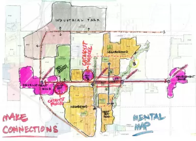
"Place" isn't just a matter of what we see before our eyes. It is also an accumulation of perceptions, histories, and even biases. That's what planner Kevin Lynch proposed in his landmark book The Image of the City, and it's a driving force in the effort to revitalize neighborhoods today.
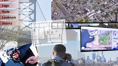
Though Lynch wasn't a neuroscientist, it turns out that many of his theories are grounded in the physiological processes that the brain uses to orient itself and direct itself through a landscape: "after our brains locate landmarks and create paths, we begin forming edges, districts, and nodes on our mental maps, once again using memories to inform the locational information. This, in essence, are where neighborhoods begin. It's also where things get nice and weird."
"It could be a very deceiving process, because you go by what you see, not by what's really there," Sorin Adam Matei, an associate professor at Purdue who researches mental maps, told Pacific Standard. "People keep saying, location, location, location. That's not objective location, really. It's suggestive location.....A physical location that was nothing 20 years ago, by getting it to the right people and with the right name, all of a sudden becomes hot." In other words, it sometimes takes a new name to erase old memories, for better or worse.
What this means is that revitalizing blighted neighborhoods may rely as much on neuroscience as on public policy.
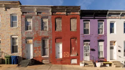
"Racist practices like redlining, used from the 1930s through the '60s to deny loans, insurance, supermarkets, and health coverage to those residing in certain neighborhoods (a practice that got its name from the literal drawing of red lines on a map to designate what areas to say blanket “nos” to), have predictably led to focused areas of blight. This has led to ensuing protests, persistent negative portrayals, a lack of funding to repair the damage, more protests, more negative portrayals, and so on."
"The first step of making improvements to any neighborhood—including the changes that are designed for original residents—comes from re-defining these quirks in our neurology. "Mental maps cannot be read apart from the stories of those who created them,” Gieseking says. "We need to be careful not only then in how we tell stories but also how we present maps."
FULL STORY: Mental Maps and the Neuroscience of Neighborhood Blight

Analyzing Lynch's City Imageability in the Digital Age
Mahbubur Meenar of Rowan University writes about a recent article he co-authored in the Journal of Planning Education and Research

What the ‘Walk Score’ Misses
A popular walkability assessment omits key factors that impact different demographics and can direct development resources to already wealthy neighborhoods.
Baltimore Program Could Repurpose Thousands of Vacant Housing Units
The city and state are investing $3 billion in rescuing vacant residential properties to promote homeownership and reduce blight.

Maui's Vacation Rental Debate Turns Ugly
Verbal attacks, misinformation campaigns and fistfights plague a high-stakes debate to convert thousands of vacation rentals into long-term housing.

Planetizen Federal Action Tracker
A weekly monitor of how Trump’s orders and actions are impacting planners and planning in America.

In Urban Planning, AI Prompting Could be the New Design Thinking
Creativity has long been key to great urban design. What if we see AI as our new creative partner?

King County Supportive Housing Program Offers Hope for Unhoused Residents
The county is taking a ‘Housing First’ approach that prioritizes getting people into housing, then offering wraparound supportive services.

Researchers Use AI to Get Clearer Picture of US Housing
Analysts are using artificial intelligence to supercharge their research by allowing them to comb through data faster. Though these AI tools can be error prone, they save time and housing researchers are optimistic about the future.

Making Shared Micromobility More Inclusive
Cities and shared mobility system operators can do more to include people with disabilities in planning and operations, per a new report.
Urban Design for Planners 1: Software Tools
This six-course series explores essential urban design concepts using open source software and equips planners with the tools they need to participate fully in the urban design process.
Planning for Universal Design
Learn the tools for implementing Universal Design in planning regulations.
planning NEXT
Appalachian Highlands Housing Partners
Mpact (founded as Rail~Volution)
City of Camden Redevelopment Agency
City of Astoria
City of Portland
City of Laramie