


Analysis of incremental tax revenues and public service costs of various development patterns in Madison, Wisconsin indicates significant economic savings from more compact land use. Modest increases in density can provide large fiscal benefits.
The city of Madison hired Smart Growth America to analyze potential development options in the city’s Pioneer District, a 1,400-acre, undeveloped area in the city. Their study evaluated five different scenarios for development: a "base" scenario that reflects the city’s current plan; a "Plus 50" scenario that assumes 50 percent higher density on certain parcels within the district; a "Compact" scenario that assumes the same development program as the base but on 500 fewer acres; a "Compact Plus 50" scenario that assumes the Plus 50 scenario on 500 fewer acres; and a "Low Density" scenario that assumes the same development as the base but on 1,000 more acres.
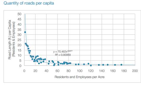
This study uses real world data to provide detailed information on how sprawl increases various government costs, including expenditures for the construction and maintenance of roadways as well as transportation to and from schools. The figure below shows that increasing density from under 5 to over 15 residents and employees per acre typically reduces road length (feet of road per resident and employee) by 50-80 percent.
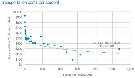
Similarly, increasing density from under 50 to over 400 pupils per square mile typically reduces school transportation costs per student by 30-80 percent.
This research provides more evidence that smart growth is literally conservative: it conserves land and municipal costs.
FULL STORY: The Fiscal Implications: Madison, WI


A Better Understanding of Smart Growth Benefits
Smart Growth creates compact, multimodal communities where residents consume less land, drive less, and rely more on non-auto modes. Planners have important stories to tell about the benefits of Smart Growth.

Shining a Light on Smarter Development Policies in India
A new study uses night sky satellite images to measure urban development patterns in India. The results can help guide smarter growth.

Study: Sprawl Costs the U.S. Economy $1 Trillion Annually
A major new study estimates that sprawl costs the U.S. economy more than a trillion dollars annually, and results, in part, from planning and market distortions. Smart policy reforms can result in more efficient and equitable development.

Planetizen Federal Action Tracker
A weekly monitor of how Trump’s orders and actions are impacting planners and planning in America.

Chicago’s Ghost Rails
Just beneath the surface of the modern city lie the remnants of its expansive early 20th-century streetcar system.

San Antonio and Austin are Fusing Into one Massive Megaregion
The region spanning the two central Texas cities is growing fast, posing challenges for local infrastructure and water supplies.

Since Zion's Shuttles Went Electric “The Smog is Gone”
Visitors to Zion National Park can enjoy the canyon via the nation’s first fully electric park shuttle system.

Trump Distributing DOT Safety Funds at 1/10 Rate of Biden
Funds for Safe Streets and other transportation safety and equity programs are being held up by administrative reviews and conflicts with the Trump administration’s priorities.

German Cities Subsidize Taxis for Women Amid Wave of Violence
Free or low-cost taxi rides can help women navigate cities more safely, but critics say the programs don't address the root causes of violence against women.
Urban Design for Planners 1: Software Tools
This six-course series explores essential urban design concepts using open source software and equips planners with the tools they need to participate fully in the urban design process.
Planning for Universal Design
Learn the tools for implementing Universal Design in planning regulations.
planning NEXT
Appalachian Highlands Housing Partners
Mpact (founded as Rail~Volution)
City of Camden Redevelopment Agency
City of Astoria
City of Portland
City of Laramie