


It often seems that streetscapes' appearances and forms are immutable, but Los Angeles is trying something new. Through a herculean effort called Recode: LA, Los Angeles is rewriting its codes and, consequently, may change how its streets look.
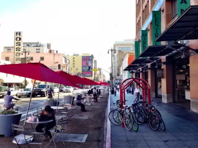
Zoning is often thought of—if it is thought of at all—as a way of regulating the uses and forms of buildings in certain parts of cities. But that’s not all, writes Mark Vallianatos, professor of urban and environmental policy at Occidental College. Zoning can also dictate the fine-grain look and functioning of a city's streets.
For Vallianatos, therefore, some of the shortcomings of Los Angeles' streets are no accident. L.A.'s car-centric, pedestrian-unfriendly streets result from zoning codes implemented in 1946. This means that L.A. has seven decades' worth of outdated streetscape. Fortunately, what was created by code may be redesigned by code. "Revised zoning rules can hopefully strengthen the ways that a 21st century Los Angeles is transforming and help residents build a city where walking is a convenient and safe way to travel," writes Vallianatos. "Zoning is potentially our most powerful tool to create a more walkable Los Angeles."
As the city works on an update to its zoning code through an effort branded as Recode: LA, Vallianatos offers recommendations for reforming the code and creating friendlier streets. They include increases in mixed-use zoning, lowering of minimum parking requirements, and encouraging pedestrian-friendly design.
FULL STORY: ReZoning Los Angeles: Can We Legalize a Walkable City?

Texas Legislature’s Surprising Pro-Housing Swing
Smaller homes on smaller lots, office to apartment conversions, and 40% less say for NIMBYs, vote state lawmakers.
Judge Rules in Favor of Massachusetts TOD Law
The court rejected an argument that the MBTA Communities law, which requires zoning for multifamily housing, is an “unfunded mandate.”
NYC Council Approves Brooklyn Rezoning Plan
The Atlantic Avenue Mixed Use Plan includes infrastructure investments and could bring 4,600 new housing units to parts of Brooklyn.

Planetizen Federal Action Tracker
A weekly monitor of how Trump’s orders and actions are impacting planners and planning in America.

Maui's Vacation Rental Debate Turns Ugly
Verbal attacks, misinformation campaigns and fistfights plague a high-stakes debate to convert thousands of vacation rentals into long-term housing.

San Francisco Suspends Traffic Calming Amidst Record Deaths
Citing “a challenging fiscal landscape,” the city will cease the program on the heels of 42 traffic deaths, including 24 pedestrians.

Amtrak Rolls Out New Orleans to Alabama “Mardi Gras” Train
The new service will operate morning and evening departures between Mobile and New Orleans.

The Subversive Car-Free Guide to Trump's Great American Road Trip
Car-free ways to access Chicagoland’s best tourist attractions.

San Antonio and Austin are Fusing Into one Massive Megaregion
The region spanning the two central Texas cities is growing fast, posing challenges for local infrastructure and water supplies.
Urban Design for Planners 1: Software Tools
This six-course series explores essential urban design concepts using open source software and equips planners with the tools they need to participate fully in the urban design process.
Planning for Universal Design
Learn the tools for implementing Universal Design in planning regulations.
Heyer Gruel & Associates PA
JM Goldson LLC
Custer County Colorado
City of Camden Redevelopment Agency
City of Astoria
Transportation Research & Education Center (TREC) at Portland State University
Jefferson Parish Government
Camden Redevelopment Agency
City of Claremont