


The Massachusetts Bay Transportation Authority, working with the University of Massachusetts Amherst, is testing an app that will help the blind navigate Arlington Station in early 2015. The app will eventually be free to use throughout the system.
"A new application being developed at the University of Massachusetts Amherst is meant to help visually impaired people navigate T stations on their own," reports Nicole Dunga.
"The MBTA has helped fund the creation of PERCEPT — an indoor navigation system that one day will allow users to make their way through a T station by listening to step-by-step directions on their smartphones, which lead them to electronic sensors or “tags” throughout the building."
FULL STORY: New app will help blind navigate MBTA stations

Boston’s Government Center T Station Closed for Access Improvements
Boston recently shut down one of its busiest transit hubs, the Government Center T Station for over-due renovations above and below the ground. The station was originally built in 1898, and without a major renovation since the 1960s.

Boston Bus Signal Priority Project Yields Faster Travel Times
The city now plans to expand a year-long pilot project that reduced the time buses waited at traffic signals.
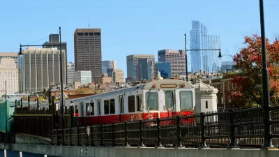
Boston Rail Network Sees Significant Increases in Speed After Eliminating ‘Slow Zones’
A year-long project that upgraded rail infrastructure and equipment has resulted in faster trips on all rail lines.

Maui's Vacation Rental Debate Turns Ugly
Verbal attacks, misinformation campaigns and fistfights plague a high-stakes debate to convert thousands of vacation rentals into long-term housing.

Planetizen Federal Action Tracker
A weekly monitor of how Trump’s orders and actions are impacting planners and planning in America.

In Urban Planning, AI Prompting Could be the New Design Thinking
Creativity has long been key to great urban design. What if we see AI as our new creative partner?

Cal Fire Chatbot Fails to Answer Basic Questions
An AI chatbot designed to provide information about wildfires can’t answer questions about evacuation orders, among other problems.

What Happens if Trump Kills Section 8?
The Trump admin aims to slash federal rental aid by nearly half and shift distribution to states. Experts warn this could spike homelessness and destabilize communities nationwide.

Sean Duffy Targets Rainbow Crosswalks in Road Safety Efforts
Despite evidence that colorful crosswalks actually improve intersection safety — and the lack of almost any crosswalks at all on the nation’s most dangerous arterial roads — U.S. Transportation Secretary Duffy is calling on states to remove them.
Urban Design for Planners 1: Software Tools
This six-course series explores essential urban design concepts using open source software and equips planners with the tools they need to participate fully in the urban design process.
Planning for Universal Design
Learn the tools for implementing Universal Design in planning regulations.
Appalachian Highlands Housing Partners
Gallatin County Department of Planning & Community Development
Heyer Gruel & Associates PA
Mpact (founded as Rail~Volution)
City of Camden Redevelopment Agency
City of Astoria
City of Portland
City of Laramie