


Across the US, cities increasingly view waterfronts as opportunities for green space. Once tied to industrial uses, river fronts now offer a chance to repurpose existing infrastructure for public use.
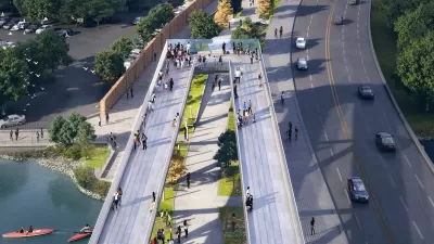
The 11th Street Bridge Park Project, one of the most prominent of these efforts, seeks to turn an aged-out freeway bridge into a three-acre civic space crossing the Anacostia River in Washington, D.C. It has garnered national attention with a recent design competition that yielded four finalists.
Scott Kratz, the project's director, discussed the initial idea and its ongoing implementation with The Planning Report. Beyond the structural concept, he detailed the intensive community outreach process and the goals this recreational area seeks to meet—including tying together two long-divided neighborhoods: "If we can create both a physical and metaphorical bridge to connect two sides of the community that rarely venture to each others’ banks, that will be a great success.”
He goes on to detail the conditions and assets east of the river, in Wards 7 and 8: "They have some of the most challenging issues, on pretty much any scale: unemployment, the health issues that we spoke about, housing insecurity, poverty, and so forth... The area has tremendous bones with extraordinarily longstanding and proud residents who perhaps haven’t had the same opportunities as those in the rest of the city... As we work with the community to help shape the vision for the park, this can be an opportunity to build economic benefits on both sides of the river."
FULL STORY: D.C's 11th Street Bridge Park: Transforming Infrastructure into Civic Space

DC Park Aims for Equitable Development
Project leaders working on the 11th Street Bridge Park hope to prevent displacement of residents and bring economic and social benefits to the surrounding community.
Philanthropy Fights Gentrification Around D.C.'s Planned Bridge Park
With lessons from high-profile urban revitalization in place, organizers and philanthropists are working to ensure the 11th Street Bridge Park doesn't push low-income residents out of surrounding neighborhoods.
Working to Ease Gentrification Around D.C.'s Ambitious 11th Street Bridge Project
From the beginning of the proposal for the new 11th Street Bridge between Anacostia and Capitol Hill, planners and designers have promised to prevent the displacement of residents living nearby the new amenities offered by the bridge and its park.

Planetizen Federal Action Tracker
A weekly monitor of how Trump’s orders and actions are impacting planners and planning in America.

Chicago’s Ghost Rails
Just beneath the surface of the modern city lie the remnants of its expansive early 20th-century streetcar system.

San Antonio and Austin are Fusing Into one Massive Megaregion
The region spanning the two central Texas cities is growing fast, posing challenges for local infrastructure and water supplies.

Since Zion's Shuttles Went Electric “The Smog is Gone”
Visitors to Zion National Park can enjoy the canyon via the nation’s first fully electric park shuttle system.

Trump Distributing DOT Safety Funds at 1/10 Rate of Biden
Funds for Safe Streets and other transportation safety and equity programs are being held up by administrative reviews and conflicts with the Trump administration’s priorities.

German Cities Subsidize Taxis for Women Amid Wave of Violence
Free or low-cost taxi rides can help women navigate cities more safely, but critics say the programs don't address the root causes of violence against women.
Urban Design for Planners 1: Software Tools
This six-course series explores essential urban design concepts using open source software and equips planners with the tools they need to participate fully in the urban design process.
Planning for Universal Design
Learn the tools for implementing Universal Design in planning regulations.
planning NEXT
Appalachian Highlands Housing Partners
Mpact (founded as Rail~Volution)
City of Camden Redevelopment Agency
City of Astoria
City of Portland
City of Laramie