


A new study, "Community Design, Street Networks, and Public Health" published in the Journal of Transport & Health finds that increased local street connectivity improves public health outcomes, apparently by encouraging more walking and cycling.
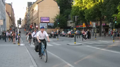
A new article, "Community Design, Street Networks, and Public Health," by professors Wesley Marshall, Daniel Piatkowski and Norman Garrick and published in the Journal of Transport & Health, finds that increased neighborhood street connectivity improves public health outcomes, apparently by encouraging more walking and cycling.
The study analyzed the street connectivity and intersection density of 24 medium-size California cities, and used health-survey data from a sampling of 42,000 to 51,000 adults for the years 2003, 2005, 2007 and 2009 to see how the intersection design affects various health outcomes. It controlled for the food environment, land uses, commuting time, socioeconomic status, and street design. The results suggest that more compact and connected street networks with fewer lanes on the major roads are correlated with reduced rates of obesity, diabetes, high blood pressure, and heart disease among residents..
This provides more evidence of the health and safety benefits of more compact, accessible and walkable communities.
Well done, Wesley, Daniel and Norman!
FULL STORY: Walkable cities mean lower obesity and disease rates, says CU Denver study

Research: Walkability Linked to Improved Public Health
A study reveals that the density of city blocks is a significant factor in communities’ walkability and, subsequently, improved public health outcomes for residents.

Study: Walkability Can Help Reduce Dementia Risk
Walkable neighborhoods offer natural opportunities to stay active and engaged with friends and neighbors, increasing residents’ chances of remaining mentally and physically healthy longer.

Take a Walk: Why Step Count Is the Most Valuable Fitness Metric
Step count remains the most valuable fitness metric for longevity and well-being, offering a simple yet powerful way to track daily movement, reduce health risks, and promote active lifestyles without reliance on complex data or technology.

Planetizen Federal Action Tracker
A weekly monitor of how Trump’s orders and actions are impacting planners and planning in America.

Restaurant Patios Were a Pandemic Win — Why Were They so Hard to Keep?
Social distancing requirements and changes in travel patterns prompted cities to pilot new uses for street and sidewalk space. Then it got complicated.

Map: Where Senate Republicans Want to Sell Your Public Lands
For public land advocates, the Senate Republicans’ proposal to sell millions of acres of public land in the West is “the biggest fight of their careers.”

Maui's Vacation Rental Debate Turns Ugly
Verbal attacks, misinformation campaigns and fistfights plague a high-stakes debate to convert thousands of vacation rentals into long-term housing.

San Francisco Suspends Traffic Calming Amidst Record Deaths
Citing “a challenging fiscal landscape,” the city will cease the program on the heels of 42 traffic deaths, including 24 pedestrians.

California Homeless Arrests, Citations Spike After Ruling
An investigation reveals that anti-homeless actions increased up to 500% after Grants Pass v. Johnson — even in cities claiming no policy change.
Urban Design for Planners 1: Software Tools
This six-course series explores essential urban design concepts using open source software and equips planners with the tools they need to participate fully in the urban design process.
Planning for Universal Design
Learn the tools for implementing Universal Design in planning regulations.
Heyer Gruel & Associates PA
JM Goldson LLC
Custer County Colorado
City of Camden Redevelopment Agency
City of Astoria
Transportation Research & Education Center (TREC) at Portland State University
Camden Redevelopment Agency
City of Claremont
Municipality of Princeton (NJ)