


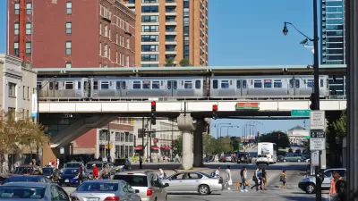
A new report challenges assumptions about Chicago's transit system, identifying well-populated neighborhoods that are cut off from frequent transit service.
John Hilkevitch shares news of a new report by the Center for Neighborhood Technology, due for release later this week. Here's how Hilkevitch summarizes the report's findings: "About 1 out of every 10 people in Cook County, roughly 438,500 residents, live in 'transit deserts' that are cut off from fast, frequent train and bus service." The study, explains Hilkevitch, "for the first time identifies dozens of Chicago-area mass transit dead zones and maps them in relation to major job clusters."
More than just residential neighborhoods lack adequate transit service, according to the report. The study also "found that four of the Chicago region's five big employment areas are in suburbs that are not well-connected to high-quality transit, making them difficult to reach without a vehicle. Those four job centers make up the northwest corridor past O'Hare International Airport, Lombard, Naperville and Oak Brook."
CTA officials, for the record, have disputed the findings of the report, saying "that more than 96 percent of the city of Chicago is not in what the study defined as a transit desert. In addition, the service levels that the study outlined to avoid the classification of a transit desert are 'standards that any transit agency in the U.S. would be unable to meet' on a 24-hour, systemwide basis, CTA spokesman Brian Steele said."
FULL STORY: 'Transit deserts' don't serve workers, study says

Chicago Transit Increasing Rail Service to Pre-Pandemic Levels
The Chicago Transit Authority is close to returning both rail and bus service to pre-pandemic schedules, with some adjustments for new travel demand.
Study: Loss of Public Transit in Chicago Would Have ‘Severe’ Mobility, Economic Consequences
The first-of-it’s kind study found that without public transit, Chicago would lose an estimated $35 billion in economic activity annually and the quality of life of residents, particularly women and low-income groups, would take a major hit.
Chicago Transit Releases 2024 Budget
The agency projects modest ridership growth while aiming to make long-term investments in bus and rail improvements.

Maui's Vacation Rental Debate Turns Ugly
Verbal attacks, misinformation campaigns and fistfights plague a high-stakes debate to convert thousands of vacation rentals into long-term housing.

Planetizen Federal Action Tracker
A weekly monitor of how Trump’s orders and actions are impacting planners and planning in America.

San Francisco Suspends Traffic Calming Amidst Record Deaths
Citing “a challenging fiscal landscape,” the city will cease the program on the heels of 42 traffic deaths, including 24 pedestrians.

Defunct Pittsburgh Power Plant to Become Residential Tower
A decommissioned steam heat plant will be redeveloped into almost 100 affordable housing units.

Trump Prompts Restructuring of Transportation Research Board in “Unprecedented Overreach”
The TRB has eliminated more than half of its committees including those focused on climate, equity, and cities.

Amtrak Rolls Out New Orleans to Alabama “Mardi Gras” Train
The new service will operate morning and evening departures between Mobile and New Orleans.
Urban Design for Planners 1: Software Tools
This six-course series explores essential urban design concepts using open source software and equips planners with the tools they need to participate fully in the urban design process.
Planning for Universal Design
Learn the tools for implementing Universal Design in planning regulations.
Heyer Gruel & Associates PA
JM Goldson LLC
Custer County Colorado
City of Camden Redevelopment Agency
City of Astoria
Transportation Research & Education Center (TREC) at Portland State University
Jefferson Parish Government
Camden Redevelopment Agency
City of Claremont