


Designed properly, roundabouts enhance placemaking and the pedestrian experience.
Rampant sprawl in Orange County, Florida, was creating rush hour back-ups half a mile long at the Town of Windermere’s quaint Main Street. The conventional solution—widening Main Street to four-lanes—would have destroyed the town’s character. Planner Brian Canin and transportation designer Jurgen Duncan instead proposed a pair of single-lane modern roundabouts with circulating speeds of 12-14 miles per hour. The Town approved construction and, to everyone’s amazement, the traffic congestion disappeared. In the low-speed environment, motorists stop for pedestrians and wave them across the street. Canin and Duncan saved Main Street.
Unlike the big, fast, scary and dangerous rotaries and traffic circles of old, compact modern roundabouts—when properly designed—reduce entry, circulating, and exit speeds to below 20 miles per hour.[i] Because kinetic energy increases as the square of velocity,[ii] a vehicle traveling 45 miles per hour through a conventional intersection has nine times the kinetic energy of one traveling 15 miles per hour through a modern roundabout.[iii] Reducing kinetic energy lessens crash severity. Intersections converted to single lane roundabouts experience a 76 percent reduction in injuries and a more than 90 percent reduction in fatalities.[iv] Roundabouts replace the “kill zone,” where deadly head-on and T-bone collisions occur, with a central island that can be beautiful.
FULL STORY: Roundabouts: A tool for placemaking


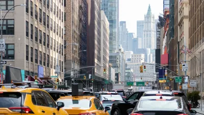
NYC Congestion Pricing Continues to Show Positive Results
While the Trump administration attempts to revoke the program’s federal approval, congestion pricing continues to reduce traffic, speed up bus travel times, and improve air quality in Manhattan.

Philadelphia Is Expanding its Network of Roundabouts
Roundabouts are widely shown to decrease traffic speed, reduce congestion, and improve efficiency.
Agreement Keeps NYC Congestion Pricing Alive Through Summer
The tolling program will continue while a court considers the city’s lawsuit against the Trump administration.

Planetizen Federal Action Tracker
A weekly monitor of how Trump’s orders and actions are impacting planners and planning in America.

San Francisco's School District Spent $105M To Build Affordable Housing for Teachers — And That's Just the Beginning
SFUSD joins a growing list of school districts using their land holdings to address housing affordability challenges faced by their own employees.

Can We Please Give Communities the Design They Deserve?
Often an afterthought, graphic design impacts everything from how we navigate a city to how we feel about it. One designer argues: the people deserve better.

The EV “Charging Divide” Plaguing Rural America
With “the deck stacked” against rural areas, will the great electric American road trip ever be a reality?

Judge Halts Brooklyn Bike Lane Removal
Lawyers must prove the city was not acting “arbitrarily, capriciously, and illegally” in ordering the hasty removal.

Engineers Gave America's Roads an Almost Failing Grade — Why Aren't We Fixing Them?
With over a trillion dollars spent on roads that are still falling apart, advocates propose a new “fix it first” framework.
Urban Design for Planners 1: Software Tools
This six-course series explores essential urban design concepts using open source software and equips planners with the tools they need to participate fully in the urban design process.
Planning for Universal Design
Learn the tools for implementing Universal Design in planning regulations.
Borough of Carlisle
Smith Gee Studio
City of Camden Redevelopment Agency
City of Astoria
Transportation Research & Education Center (TREC) at Portland State University
City of Camden Redevelopment Agency
Municipality of Princeton (NJ)