


The biggest mobility challenge in cities isn't about what comes out of a car's tailpipe - it's about the massive amount of space that cars demand. Space to drive in, and space to park in. When explaining this, these pictures are worth 1000 words.

As gas prices rise and the hype ramps up again about electric cars as the "solution" to green mobility in cities, I find myself busy once again pointing out that the biggest challenge in cities when it comes to how we get around, isn't about what comes out of the tailpipe of your car.
Even if all vehicles became electric tomorrow (which they won't), and even if your local electric energy sources are on the renewable side, like BC's hydro-electric power (which they're likely not - it's just as likely they're on the especially dirty side, like coal), the truth is there's no totally "clean" energy source, no energy without impacts. The only real energy solutions are urban densities, use-mixes and patterns, and personal choices, that depend on much less energy. That means efforts like making walking, biking and public transit truly inviting options in our cities and communities.
Regardless of the energy source for cars in your community, the biggest mobility challenge in cities is the massive amount of space that cars demand. Space to drive in, and space to park in. Space for cars even when the cars aren't using it - dedicated space for "potential cars." It's staggering really, how much of a city is set aside for cars, and how unwilling we often are to even share that space with other uses and users.
Electric cars do nothing to address this space issue.
The simplest messages are usually the most effective when it comes to connecting mobility and space, and as the saying goes, a picture is worth at least a thousand words. So when I discuss the inter-relationship between land-use and mobility, the "law of congestion," how multi-modal cities actually work better for everyone, including drivers, and why it's important that we prioritize walking, biking and transit, I like to include images like this rather beautiful decades-old poster from London:

Even back in the '60's, big cities like London understood the mobility-space connection, and tried to explain it simply to their citizens. This particular image didn't include cycling in the "urban space continuum" - but more recent ones do, and I like to include as many as I can from cities around the world that have done similar exercises. I suppose I'm collecting them!


Have I missed any? Wouldn't it be great if advocates or city hall staff in every city arranged a photo shoot like this, invited the media, and put the resulting image on their local front page? If nothing else, it's a great conversation starter about how cities work.
If photos aren't your favourite way to convey the space point, how about cartoons?


Maybe you prefer the design creativity that's popping up in cities like Buenos Aires and London, where the design of bike parking also makes a point about how many bikes can be parked in the space normally needed for a car?

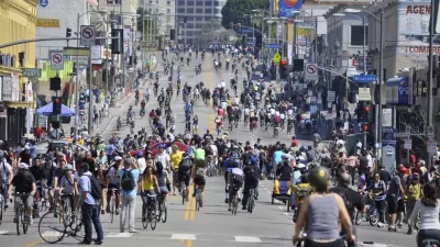
Or maybe you want to emphasize that the most impressive space saving in cities comes from pedestrians. With this image below, you don't have to imagine how much space it would take if every pedestrian needed as much space as a car.

In my recent work in Sydney, Australia, I discovered that Sydney Transport had taken a shot at the math on how to move 1000 people into the Central Business District - 1 train, 15 buses, or up to 1000 cars needing 1.37 hectares of CBD parking. The only downside of this persuasive message is that you have to go to the web-page of Sydney Transport to find it - wouldn't it be great to find it on the front page of the local papers?

The truth is, as powerful as these images are in making the point, they're not really accurate. The space difference shown only reflects when vehicles aren't moving - when they're parked. When vehicles are moving, they take up much more space. The faster they move, the more separation distance and space between vehicles is needed. So these images are actually significantly understating the point. My friend Todd Litman of the Victoria Transport Policy Institute has explained this and other space related factors very well.

After initially posting this article (and in response to it), I received this even more detailed comparison of the space requirements of different ways of getting around, from Bill Gehling of WalkingSA in South Australia - thanks Bill! Note that walking is so infrastructure (and cost)-efficient, it doesn't even show up on the graph. Note also the small per-person space needs of trains, even when only half full.

In a recent discussion I had with a Colombian transportation planner in Bogotá, their math suggested that mobility by car takes 20 times more space per person within cities than tram-ways, & 90 times more space per person than subways/metros. I haven't check their math, but I found it interesting how it was a key part of the public discussion about transportation in their city.
Of course if walking, biking and transit are space savers, that means they're also money savers, reducers of a city's carbon footprint, facilitators of more healthy, economically successful cities, and so on. They make cities work better, period. When you start to connect the dots on space and mobility in cities, the picture gets bigger and clearer.
This might be my shortest Planetizen post so far - well, in words, anyway. But if you add up all the 1000's of words in these powerful images, I hope this post speaks volumes about how mobility, and better city-making, is about using our urban space more intelligently.

Portland Learning from Los Angeles
An interdisciplinary team of urban designers, architects, and analysts have proposed a neo-retro-futurist scenario for making downtown Portland nearly car-free by 2050.
Did the Pandemic Spur Radical Urban Change?
The Covid era highlighted social inequities and prompted new paradigms for urbanism and mobility. Will they stick around?
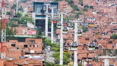
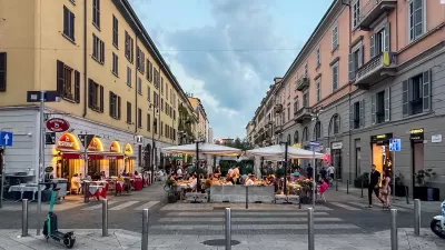
3 Reasons We Should Pay Attention to Medellín
Medellín has been called the most innovative city in the world, and recently hosted the World Urban Forum WUF7 to huge acclaim. It has taken back the city's public realm, found simple solutions to complex problems, and emphasized a "City for Life."

Maui's Vacation Rental Debate Turns Ugly
Verbal attacks, misinformation campaigns and fistfights plague a high-stakes debate to convert thousands of vacation rentals into long-term housing.

Planetizen Federal Action Tracker
A weekly monitor of how Trump’s orders and actions are impacting planners and planning in America.

In Urban Planning, AI Prompting Could be the New Design Thinking
Creativity has long been key to great urban design. What if we see AI as our new creative partner?

Massachusetts Budget Helps Close MBTA Budget Gap
The budget signed by Gov. Maura Healey includes $470 million in MBTA funding for the next fiscal year.

Milwaukee Launches Vision Zero Plan
Seven years after the city signed its Complete Streets Policy, the city is doubling down on its efforts to eliminate traffic deaths.

Portland Raises Parking Fees to Pay for Street Maintenance
The city is struggling to bridge a massive budget gap at the Bureau of Transportation, which largely depleted its reserves during the Civd-19 pandemic.
Urban Design for Planners 1: Software Tools
This six-course series explores essential urban design concepts using open source software and equips planners with the tools they need to participate fully in the urban design process.
Planning for Universal Design
Learn the tools for implementing Universal Design in planning regulations.
Gallatin County Department of Planning & Community Development
Heyer Gruel & Associates PA
JM Goldson LLC
City of Camden Redevelopment Agency
City of Astoria
Transportation Research & Education Center (TREC) at Portland State University
Jefferson Parish Government
Camden Redevelopment Agency
City of Claremont