


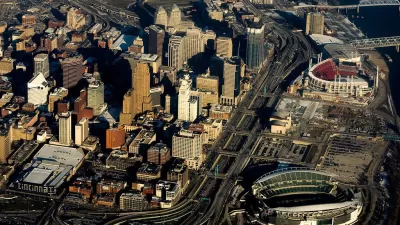
In a collection of aerial photos comparing Cincinnati in the 1950s and today, one can see the disastrous effect that the nation's highway building frenzy had on the city's urban fabric.
Across the United States, the post-war rush to build a national network of highways had a profound impact on the country's urban and rural landscapes. At the same time that they were facilitating the growth of the suburbs, urban highways were destroying long-standing, often minority, neighborhoods - a wound from which many cities are still trying to recover.
With stunning before and after photographs of Cincinnati's West End and the area around Union Terminal, Aaron M. Renn shows just how much was lost when the city chose to plan for cars instead of people.
FULL STORY: In Case You’ve Forgotten How Badly Freeways Damaged Our Cities, Cincinnati Edition

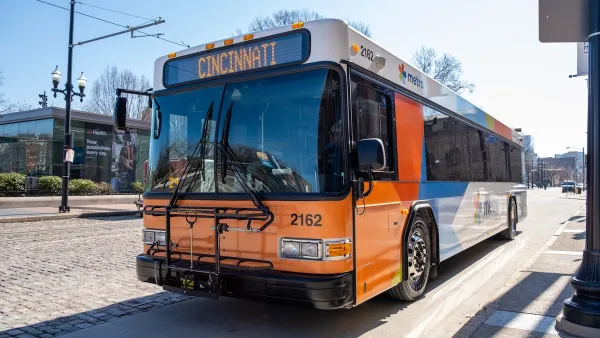
Cincinnati School District Shifts Students to Public Transit to Cut Costs
Over 10,000 Cincinnati Public Schools students already use public buses for school transportation each year.

Cincinnati ADU Legalization Slow to Catch On
Only four permits have been filed since the city made ‘granny flats’ legal last year.

Cincinnati Bike Share System To Relaunch May 13
The Red Bike system suspended operations in March, but has since raised funds through a private campaign to resume service.

Planetizen Federal Action Tracker
A weekly monitor of how Trump’s orders and actions are impacting planners and planning in America.

Restaurant Patios Were a Pandemic Win — Why Were They so Hard to Keep?
Social distancing requirements and changes in travel patterns prompted cities to pilot new uses for street and sidewalk space. Then it got complicated.

Map: Where Senate Republicans Want to Sell Your Public Lands
For public land advocates, the Senate Republicans’ proposal to sell millions of acres of public land in the West is “the biggest fight of their careers.”

Maui's Vacation Rental Debate Turns Ugly
Verbal attacks, misinformation campaigns and fistfights plague a high-stakes debate to convert thousands of vacation rentals into long-term housing.

San Francisco Suspends Traffic Calming Amidst Record Deaths
Citing “a challenging fiscal landscape,” the city will cease the program on the heels of 42 traffic deaths, including 24 pedestrians.

California Homeless Arrests, Citations Spike After Ruling
An investigation reveals that anti-homeless actions increased up to 500% after Grants Pass v. Johnson — even in cities claiming no policy change.
Urban Design for Planners 1: Software Tools
This six-course series explores essential urban design concepts using open source software and equips planners with the tools they need to participate fully in the urban design process.
Planning for Universal Design
Learn the tools for implementing Universal Design in planning regulations.
Heyer Gruel & Associates PA
JM Goldson LLC
Custer County Colorado
City of Camden Redevelopment Agency
City of Astoria
Transportation Research & Education Center (TREC) at Portland State University
Camden Redevelopment Agency
City of Claremont
Municipality of Princeton (NJ)