


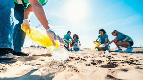
Utilizing an online tool that compares images from Google Street View, researchers have built a better understanding of the 'small, often imperceptible reasons' that make some streets and places feel safer than others.
In an effort to better understand perceptions of urban safety, researchers Phile Salesses, Katja Schechtner and César A. Hidalgo built an online tool that asks users to compare images from Boston, New York, and the Austrian cities of Salzburg and Linz. In a paper recently published in PLOS ONE, the authors discuss some of the patterns they've observed.
"We found images with trash in it, and took the trash out, and we noticed a 30 percent increase in perception of safety," Salesses says. "It's surprising that something that easy had that large an effect."
"This also means some fairly cost-effective government interventions – collecting trash – could have a significant impact on how safe people feel in a neighborhood," adds Emily Badger. "Ideally, in the future, [Salesses] envisions officials using a tool like this to do cost-benefit analyses of removing trash or planting new trees: Where should cities spend scarce resources to produce the greatest improvements in how people perceive a place?"
FULL STORY: The Small, Often Imperceptible Reasons Some Neighborhoods Feel Safer Than Others

Plastic Bag Bans Actually Worked
U.S. coastal areas with plastic bag bans or fees saw significant reductions in plastic bag pollution — but plastic waste as a whole is growing.
How Public Spaces Exclude Teen Girls
Adolescent girls face unique challenges and concerns when navigating public spaces. We can design cities with their needs in mind.
Nightlife and the 15-Minute City
Plans for compact, walkable cities often don’t address nighttime concerns like transportation and lighting, which can make neighborhoods more vibrant and safe around the clock.

Planetizen Federal Action Tracker
A weekly monitor of how Trump’s orders and actions are impacting planners and planning in America.

Maui's Vacation Rental Debate Turns Ugly
Verbal attacks, misinformation campaigns and fistfights plague a high-stakes debate to convert thousands of vacation rentals into long-term housing.

San Francisco Suspends Traffic Calming Amidst Record Deaths
Citing “a challenging fiscal landscape,” the city will cease the program on the heels of 42 traffic deaths, including 24 pedestrians.

Amtrak Rolls Out New Orleans to Alabama “Mardi Gras” Train
The new service will operate morning and evening departures between Mobile and New Orleans.

The Subversive Car-Free Guide to Trump's Great American Road Trip
Car-free ways to access Chicagoland’s best tourist attractions.

San Antonio and Austin are Fusing Into one Massive Megaregion
The region spanning the two central Texas cities is growing fast, posing challenges for local infrastructure and water supplies.
Urban Design for Planners 1: Software Tools
This six-course series explores essential urban design concepts using open source software and equips planners with the tools they need to participate fully in the urban design process.
Planning for Universal Design
Learn the tools for implementing Universal Design in planning regulations.
Heyer Gruel & Associates PA
JM Goldson LLC
Custer County Colorado
City of Camden Redevelopment Agency
City of Astoria
Transportation Research & Education Center (TREC) at Portland State University
Jefferson Parish Government
Camden Redevelopment Agency
City of Claremont