


A number of recent reports have examined the growing levels of poverty found in America's suburbs. An interactive map developed by the Urban Institute makes the dimensions and trajectories of that growth clear.
As Emily Badger reports, "the Urban Institute recently created a helpful new mapping tool that tracks fine-grained Census data on poverty for every metropolitan area of the country, spanning the years from 1980-2010. The patterns vary by city (Chicago Magazine has a good discussion of what the tool illustrates there). Just about everywhere, however, poverty appears to be spreading."
"In some cities, like Milwaukee, it remains racially segregated, with the black poor living in one part of town, the white poor in another, and the Hispanic and Asian poor in separate pockets. In other cities, like Houston, racially diverse families living under the poverty line appear to share some of the same neighborhoods."
FULL STORY: Poverty Maps From 1980 Look Astonishingly Different Compared to 2010

Looking for the Causes of Suburban Poverty
Why is poverty increasing in the suburbs? It's not as simple as blaming the shifting demographics of the urban core.

Responses to the Suburbanization of Poverty in Short Supply
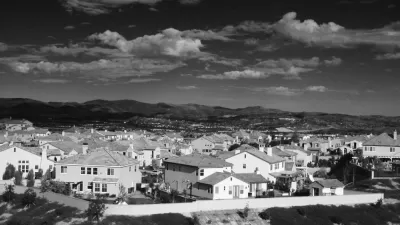
Low-income residents have scattered to the periphery, where social services are less accessible.

New Poverty and Income Data Reveals a Tale of Two Types of Cities
While the country overall made progress, larger cities are making stronger gains against poverty.

Planetizen Federal Action Tracker
A weekly monitor of how Trump’s orders and actions are impacting planners and planning in America.

Restaurant Patios Were a Pandemic Win — Why Were They so Hard to Keep?
Social distancing requirements and changes in travel patterns prompted cities to pilot new uses for street and sidewalk space. Then it got complicated.

Map: Where Senate Republicans Want to Sell Your Public Lands
For public land advocates, the Senate Republicans’ proposal to sell millions of acres of public land in the West is “the biggest fight of their careers.”

Maui's Vacation Rental Debate Turns Ugly
Verbal attacks, misinformation campaigns and fistfights plague a high-stakes debate to convert thousands of vacation rentals into long-term housing.

San Francisco Suspends Traffic Calming Amidst Record Deaths
Citing “a challenging fiscal landscape,” the city will cease the program on the heels of 42 traffic deaths, including 24 pedestrians.

California Homeless Arrests, Citations Spike After Ruling
An investigation reveals that anti-homeless actions increased up to 500% after Grants Pass v. Johnson — even in cities claiming no policy change.
Urban Design for Planners 1: Software Tools
This six-course series explores essential urban design concepts using open source software and equips planners with the tools they need to participate fully in the urban design process.
Planning for Universal Design
Learn the tools for implementing Universal Design in planning regulations.
Heyer Gruel & Associates PA
JM Goldson LLC
Custer County Colorado
City of Camden Redevelopment Agency
City of Astoria
Transportation Research & Education Center (TREC) at Portland State University
Camden Redevelopment Agency
City of Claremont
Municipality of Princeton (NJ)