


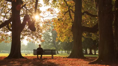
In Washington D.C., double the amount of residents in affluent areas live among plentiful green spaces. Lessening the disparity will require the cooperation of private property owners, not all of whom see more trees as a good thing.
Nearly 40 percent of residents in low-income areas live in places with fewer trees and more empty spaces. Meanwhile, 80 percent of residents in upper-income areas live in well-planted neighborhoods, according to the Post analysis, which rated neighborhoods on a percentage scale that reflects existing trees and open space that could in theory be planted."
"The city and nonprofit groups have been trying to plant at least 8,600 trees a year in the District in an effort to increase the canopy to 40 percent in the next two decades," add Gowen and Mellnik. "Working with neighbors is becoming more important in preserving the tree canopy, because much of the plantable land left is in private yards rather than in parks and other public spaces."
But getting buy-in from residents in some areas will be a challenge.
"Doris Gudger of Anacostia is among those who see little to like about lots of trees. When city crews showed up one recent day and planted some in front of her rowhouse in Southeast Washington, she wanted them gone."
"The pollen would aggravate her allergies, she said. The leaves would be a pain to rake. The shade would draw drug dealers. And, she feared, soon would follow affluent gentrifiers and higher taxes, pushing out older residents like herself."
FULL STORY: Tree canopy’s density indicates wealth of D.C. neighborhoods

‘Smart Surfaces’ Policy Guide Offers Advice for Building and Maintaining Urban Tree Canopies
Healthy, robust tree canopies can reduce the impacts of extreme heat and improve air quality.
Alabama School Forestry Initiative Brings Trees to Schoolyards
Trees can improve physical and mental health for students and commnity members.
LA’s Tree Emergency Goes Beyond Vandalism
After a vandal destroyed dozens of downtown LA trees, Mayor Karen Bass vowed to replace them. Days later, she slashed the city’s tree budget.

Planetizen Federal Action Tracker
A weekly monitor of how Trump’s orders and actions are impacting planners and planning in America.

Restaurant Patios Were a Pandemic Win — Why Were They so Hard to Keep?
Social distancing requirements and changes in travel patterns prompted cities to pilot new uses for street and sidewalk space. Then it got complicated.

Map: Where Senate Republicans Want to Sell Your Public Lands
For public land advocates, the Senate Republicans’ proposal to sell millions of acres of public land in the West is “the biggest fight of their careers.”

Maui's Vacation Rental Debate Turns Ugly
Verbal attacks, misinformation campaigns and fistfights plague a high-stakes debate to convert thousands of vacation rentals into long-term housing.

San Francisco Suspends Traffic Calming Amidst Record Deaths
Citing “a challenging fiscal landscape,” the city will cease the program on the heels of 42 traffic deaths, including 24 pedestrians.

California Homeless Arrests, Citations Spike After Ruling
An investigation reveals that anti-homeless actions increased up to 500% after Grants Pass v. Johnson — even in cities claiming no policy change.
Urban Design for Planners 1: Software Tools
This six-course series explores essential urban design concepts using open source software and equips planners with the tools they need to participate fully in the urban design process.
Planning for Universal Design
Learn the tools for implementing Universal Design in planning regulations.
Heyer Gruel & Associates PA
JM Goldson LLC
Custer County Colorado
City of Camden Redevelopment Agency
City of Astoria
Transportation Research & Education Center (TREC) at Portland State University
Camden Redevelopment Agency
City of Claremont
Municipality of Princeton (NJ)