


The Project for Public Spaces has released its "Rightsizing Streets Guide", which "aims to help planners and community members update their streets to make them ‘right’ for their context."
In recent years, communities across the country have pursued "road diet" projects to adapt streets that had primarily facilitated the fast movement of autmobiles into assets for all users. In response to this growing trend, PPS has assembled a "Rightsizing Streets Guide" to provide engineers, planners, and community members with techniques and best practices for adapting their streets.
"Our glossary of common rightsizing techniques and our best practices guide to street selection criteria and before and after measurements can help facilitate similar changes in your community," says PPS Senior Director Gary Toth. "The centerpiece of the guide is a set of ten rightsizing case studies that highlight impressive outcomes using before and after data on mobility, crashes, and other parameters. These are just a few of the projects that have been built and many more are being planned all over the country."
FULL STORY: Welcome to the Rightsizing Streets Guide

Shrinking Cities Seek to Shrink Streets
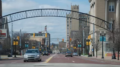
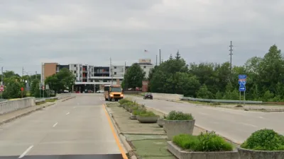
In Rust Belt cities like Flint, Michigan, a loss of population translates to less cars on oversized streets. Angie Schmitt examines how Flint, and other cities like it, are trying to right-size their transportation infrastructure.

Milwaukee Road to Get Complete Streets Upgrades
The city will reduce vehicle lanes and build a protected multi-use trail including bioswales and other water retention features on its ‘secret highway.’
Indy Neighborhood Group Builds Temporary Multi-Use Path
Community members, aided in part by funding from the city, repurposed a vehicle lane to create a protected bike and pedestrian path for the summer season.

Planetizen Federal Action Tracker
A weekly monitor of how Trump’s orders and actions are impacting planners and planning in America.

Maui's Vacation Rental Debate Turns Ugly
Verbal attacks, misinformation campaigns and fistfights plague a high-stakes debate to convert thousands of vacation rentals into long-term housing.

San Francisco Suspends Traffic Calming Amidst Record Deaths
Citing “a challenging fiscal landscape,” the city will cease the program on the heels of 42 traffic deaths, including 24 pedestrians.

Defunct Pittsburgh Power Plant to Become Residential Tower
A decommissioned steam heat plant will be redeveloped into almost 100 affordable housing units.

Trump Prompts Restructuring of Transportation Research Board in “Unprecedented Overreach”
The TRB has eliminated more than half of its committees including those focused on climate, equity, and cities.

Amtrak Rolls Out New Orleans to Alabama “Mardi Gras” Train
The new service will operate morning and evening departures between Mobile and New Orleans.
Urban Design for Planners 1: Software Tools
This six-course series explores essential urban design concepts using open source software and equips planners with the tools they need to participate fully in the urban design process.
Planning for Universal Design
Learn the tools for implementing Universal Design in planning regulations.
Heyer Gruel & Associates PA
JM Goldson LLC
Custer County Colorado
City of Camden Redevelopment Agency
City of Astoria
Transportation Research & Education Center (TREC) at Portland State University
Jefferson Parish Government
Camden Redevelopment Agency
City of Claremont