


For those that dream of traveling the length of the Golden State without getting behind the wheel of an automobile, a new map shows the interconnected system of trains and buses that can get you from San Diego to Eureka and in-between.
Aaron Bialick shares the new California Rail Map, a map of transit throughout the Golden State. Created by Alfred Twu and his team of cartographers, the map features “both intracity and regional rail lines as well as connecting buses, proving once and for all that it’s possible to get to almost anywhere in the state on public transit,” says Twu.
"The map ties together networks for Amtrak, BART, Muni, VTA, Caltrain, Altamont Commuter Express, Sacramento Regional Transit, San Diego North County Transit District (NCTD), San Diego Trolley, LA Metro, and Metrolink, as well as key bus and ferry connections."
And though the map includes more than 500 destinations reachable by train or connecting bus or ferry, you may want to time your trip with Google Maps before you plan to travel between Palm Springs and Yosemite.
FULL STORY: New California Transit Map Simplifies Car-Free Travel Across the State

Mapping Climate Impact at the Neighborhood Level
A consumption-based analysis illustrates the differences in average household emissions across census tracts.
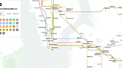
The New New York Subway Map Works in Real Time
There's a new chapter, and maybe an end, for the "Great Subway Map Debate."
Coming Soon: A New Transit Map for Philadelphia
Transit is getting a new look.

Planetizen Federal Action Tracker
A weekly monitor of how Trump’s orders and actions are impacting planners and planning in America.

Chicago’s Ghost Rails
Just beneath the surface of the modern city lie the remnants of its expansive early 20th-century streetcar system.

San Antonio and Austin are Fusing Into one Massive Megaregion
The region spanning the two central Texas cities is growing fast, posing challenges for local infrastructure and water supplies.

Since Zion's Shuttles Went Electric “The Smog is Gone”
Visitors to Zion National Park can enjoy the canyon via the nation’s first fully electric park shuttle system.

Trump Distributing DOT Safety Funds at 1/10 Rate of Biden
Funds for Safe Streets and other transportation safety and equity programs are being held up by administrative reviews and conflicts with the Trump administration’s priorities.

German Cities Subsidize Taxis for Women Amid Wave of Violence
Free or low-cost taxi rides can help women navigate cities more safely, but critics say the programs don't address the root causes of violence against women.
Urban Design for Planners 1: Software Tools
This six-course series explores essential urban design concepts using open source software and equips planners with the tools they need to participate fully in the urban design process.
Planning for Universal Design
Learn the tools for implementing Universal Design in planning regulations.
planning NEXT
Appalachian Highlands Housing Partners
Mpact (founded as Rail~Volution)
City of Camden Redevelopment Agency
City of Astoria
City of Portland
City of Laramie