


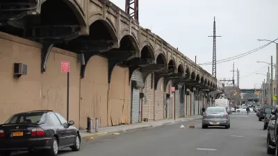
After 5 decades of abandonment, and recent inspiration from the much-lauded High Line, a rusty railway stretching three-and-a-half miles through central Queens may become NYC’s next elevated greenway.
Lisa W. Foderaro reports: “'QueensWay' [is being reconceived as a] would-be linear park for walkers and bicyclists in an area desperate for more parkland and, with the potential for art installations, performances and adjacent restaurants, a draw for tourists interested in sampling the famously diverse borough.” Many feel the project is long overdue and supporters like Will Rogers, president and chief executive officer of the Trust for Public Land, say that “[i]t’s Queens’s turn” to soak in some of New York City's limelight.
Though potential obstacles include fund raising challenges, Foderaro highlights progress already made: "the trust has already raised tens of thousands of dollars for the project, in addition to the state grant [that will fund a community planning survey and feasibility study].” She also vets the land trust's capacity, adding that “it has broad experience in fostering linear parks, having worked on four dozen such parks, mostly on ground level, around the country," including the Bloomingdale Trail, an elevated railway to park conversion in Chicago.
Many apparently stand to benefit from the development. “About 250,000 residents live within a mile of the proposed park, and its backers see all kinds of ancillary benefits, from health to traffic,” says Foderaro.
QueensWay differentiates itself from the High Line in several ways. For one, the city already owns the land in question, and will not need to acquire it, as it did with the High Line. Also, the project does not call for the reconstruction of “a steel structure... requir[ing] nothing more than the clearing of tracks, the selective removal of trees and the pouring of asphalt” in some places. QueensWay will also welcome bicycles, now prohibited on the High Line. Finally, QueensWay is being promoted as a ‘cultural trail’ that "will be defined by the neighborhoods it passes through” in contrast to the High Line, which re-defined its surrounding neighborhoods.
FULL STORY: In Queens, Taking the High Line as a Model

Plans for Queens' 'High Line' Has Competition: Bringing Back the Train
Queen's version of Manhattan's High Line is known as the QueensWay, an abandoned LIRR branch that went from Rego Park to Rockaway. Two congressmen have now endorsed a plan to bring the train back - though planning for the new park has already begun.
Design for Chicago's Bloomingdale Trail Takes Shape
As it wraps up the first stage of a community planning progress, Alan G. Brake checks in on the latest designs for Chicago's answer to the High Line.
All Aboard for Chicago's Massive Rail to Trail Conversion
Lisa Donovan reports that the city of Chicago has plugged a $9 million shortfall in funding required to begin construction on the long-anticipated Bloomingdale Trail project.

Maui's Vacation Rental Debate Turns Ugly
Verbal attacks, misinformation campaigns and fistfights plague a high-stakes debate to convert thousands of vacation rentals into long-term housing.

Planetizen Federal Action Tracker
A weekly monitor of how Trump’s orders and actions are impacting planners and planning in America.

San Francisco Suspends Traffic Calming Amidst Record Deaths
Citing “a challenging fiscal landscape,” the city will cease the program on the heels of 42 traffic deaths, including 24 pedestrians.

Defunct Pittsburgh Power Plant to Become Residential Tower
A decommissioned steam heat plant will be redeveloped into almost 100 affordable housing units.

Trump Prompts Restructuring of Transportation Research Board in “Unprecedented Overreach”
The TRB has eliminated more than half of its committees including those focused on climate, equity, and cities.

Amtrak Rolls Out New Orleans to Alabama “Mardi Gras” Train
The new service will operate morning and evening departures between Mobile and New Orleans.
Urban Design for Planners 1: Software Tools
This six-course series explores essential urban design concepts using open source software and equips planners with the tools they need to participate fully in the urban design process.
Planning for Universal Design
Learn the tools for implementing Universal Design in planning regulations.
Heyer Gruel & Associates PA
JM Goldson LLC
Custer County Colorado
City of Camden Redevelopment Agency
City of Astoria
Transportation Research & Education Center (TREC) at Portland State University
Jefferson Parish Government
Camden Redevelopment Agency
City of Claremont