


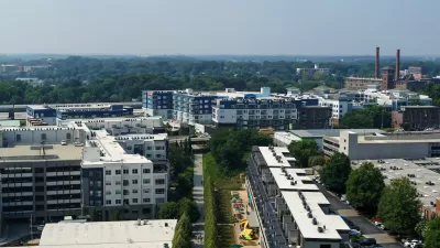
Despite recent controversy that claimed the BeltLine Inc’s president, when the 2.25-mile Eastside Trail opens this week, Atlanta's long-awaited Beltline will take its “most significant step forward yet,” reports Bill Torpy.
The vision for converting an abandoned railway corridor circling downtown Atlanta into a network of public parks, multi-use trails and transit - known as the BeltLine - began life as a doctoral thesis by Georgia Tech student Ryan Gravel in 1999. With Monday's opening of the Eastside Trail, Gravel's vision, which saw its transit plan take a hit with the rejection of a proposed transit sales tax in July, is facing another reality check.
"Ed McBrayer, executive director of PATH, the organization
charged with the corridor's construction oversight, calls this section 'a big first step. This will be a model case to see if the Beltline can
be all that we think it can be,' he said. 'This starts a network we've
been looking for, for 20 years. It will be a trail connecting Fernbank
to Centennial Park (downtown) to the MLK Center, to Piedmont Park to
Freedom Parkway. You can travel to a lot of destinations that mean
something.'"
Also, McBrayer added, "This section will either prove
or disprove that economic development will follow greenspace as we think
it might."
FULL STORY: Beltline a walk in the park

Atlanta Beltline Acquires Major Piece of the Future Eastside Trail
The Atlanta Beltline will be realized one step at a time, and this was a big one.
New Study Commissioned for Atlanta BeltLine Transit
The study will assess alignment options for a 13-mile segment of the greenway.

Atlanta Streetcar Expansion Still Moving Forward
MARTA has drastically reduced its plans to construct new rail transit, but one project still has political support from the top at City Hall.

Planetizen Federal Action Tracker
A weekly monitor of how Trump’s orders and actions are impacting planners and planning in America.

Maui's Vacation Rental Debate Turns Ugly
Verbal attacks, misinformation campaigns and fistfights plague a high-stakes debate to convert thousands of vacation rentals into long-term housing.

San Francisco Suspends Traffic Calming Amidst Record Deaths
Citing “a challenging fiscal landscape,” the city will cease the program on the heels of 42 traffic deaths, including 24 pedestrians.

Amtrak Rolls Out New Orleans to Alabama “Mardi Gras” Train
The new service will operate morning and evening departures between Mobile and New Orleans.

The Subversive Car-Free Guide to Trump's Great American Road Trip
Car-free ways to access Chicagoland’s best tourist attractions.

San Antonio and Austin are Fusing Into one Massive Megaregion
The region spanning the two central Texas cities is growing fast, posing challenges for local infrastructure and water supplies.
Urban Design for Planners 1: Software Tools
This six-course series explores essential urban design concepts using open source software and equips planners with the tools they need to participate fully in the urban design process.
Planning for Universal Design
Learn the tools for implementing Universal Design in planning regulations.
Heyer Gruel & Associates PA
JM Goldson LLC
Custer County Colorado
City of Camden Redevelopment Agency
City of Astoria
Transportation Research & Education Center (TREC) at Portland State University
Jefferson Parish Government
Camden Redevelopment Agency
City of Claremont