


More people leave the 9-county region than migrate there from other states. In fact, the population would be in decline if it wasn't for foreign migration. Notably missing from the report on Census data is the birth rate for the region.
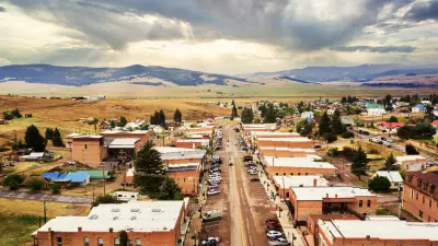
Aaron Glantz compiled the findings from data supplied by the U.S. Census Bureau. Bar graphs of in and out migration are shown for each of the 9 counties composing the San Francisco Bay region. Only San Francisco had more people moving out of the county than into it.
"Approximately 400,000 local residents move [sic] out of the Bay Area every year between 2005 and 2009, while just 345,000 people moved here from other parts of the country - a loss of about 55,000 residents annually. But about 71,000 people moved to the Bay Area from other nations during each of those years, contributing to the region's population growth."
Santa Clara county, home to Silicon Valley, saw the most pronounced population shift "where 24,000 new immigrants arrived as 83,000 residents left."
"Professor James Lai, who heads the ethnic studies department at Santa Clara University, blamed the gap on high-tech companies that, he said, preferred to hire immigrants on temporary work visas "because they are cheaper."
"Many of the people who left the Bay Area headed to the Central Valley, where the cost of living is lower, or to warmer, more sprawling cities, including Los Angeles, Las Vegas and Phoenix, the data show."
Thanks to The Bay Citizen
FULL STORY: Bay Area Residents Leaving in Droves


The Five Most-Changed American Cities
A ranking of population change, home values, and jobs highlights the nation’s most dynamic and most stagnant regions.
Rural Population Grew Again in 2024
Americans continued to move to smaller towns and cities, resulting in a fourth straight year of growth in rural areas.

Small Towns Grow Faster Than Cities for First Time in Decades
Cities of 4 million or more people lost 600,000 residents to domestic migration.

Planetizen Federal Action Tracker
A weekly monitor of how Trump’s orders and actions are impacting planners and planning in America.

Maui's Vacation Rental Debate Turns Ugly
Verbal attacks, misinformation campaigns and fistfights plague a high-stakes debate to convert thousands of vacation rentals into long-term housing.

San Francisco Suspends Traffic Calming Amidst Record Deaths
Citing “a challenging fiscal landscape,” the city will cease the program on the heels of 42 traffic deaths, including 24 pedestrians.

Defunct Pittsburgh Power Plant to Become Residential Tower
A decommissioned steam heat plant will be redeveloped into almost 100 affordable housing units.

Trump Prompts Restructuring of Transportation Research Board in “Unprecedented Overreach”
The TRB has eliminated more than half of its committees including those focused on climate, equity, and cities.

Amtrak Rolls Out New Orleans to Alabama “Mardi Gras” Train
The new service will operate morning and evening departures between Mobile and New Orleans.
Urban Design for Planners 1: Software Tools
This six-course series explores essential urban design concepts using open source software and equips planners with the tools they need to participate fully in the urban design process.
Planning for Universal Design
Learn the tools for implementing Universal Design in planning regulations.
Heyer Gruel & Associates PA
JM Goldson LLC
Custer County Colorado
City of Camden Redevelopment Agency
City of Astoria
Transportation Research & Education Center (TREC) at Portland State University
Jefferson Parish Government
Camden Redevelopment Agency
City of Claremont