


The inconsistent signage, representing 26 different public transportation systems in the Bay Area, leaves many riders feeling lost. Julie Caine describes the confusion and improvements underway.
When Transportation Nation reporter, Julie Caine, finds Hattam Moktor he is standing near an empty station agent's booth trying to make sense of the transit system. Together they examine his map and get him pointed in the right direction, but it's no easy task distinguishing the various train and bus systems that connect San Francisco.
Users of this system, however, will be pleased to learn that the Metropolitan Transportation Commission (MTC) has committed to updating transit signage throughtout the area. Caine visits with Sue Labouvie, the graphic designer charged with redesigning the Bay Area's wayfinding system. Labouvie describes the value of consistent wayfinding designs: "It is all about reducing stress, increasing clarity." The next few months should bring some clarity to riders as the new signage appears across the area.
Thanks to Jessica Brent
FULL STORY: In the Bay Area, Transit Signs are Surprisingly Poor


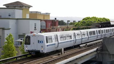
BART Closes $35 Million Deficit
Cost control and revenue generation measures prevented service cuts.

Bay Area Proposal Calls for Combined Transit Agencies
A local legislator is asking for a plan to consolidate the region’s 27 separate transit agencies to improve financial stability and streamline service for riders.
California Bill Would Mandate Seamless Transit
With 27 transit agencies, traveling across the Bay Area can be a daunting task. Advocates for 'seamless transit' want to change that.

Maui's Vacation Rental Debate Turns Ugly
Verbal attacks, misinformation campaigns and fistfights plague a high-stakes debate to convert thousands of vacation rentals into long-term housing.

Planetizen Federal Action Tracker
A weekly monitor of how Trump’s orders and actions are impacting planners and planning in America.

In Urban Planning, AI Prompting Could be the New Design Thinking
Creativity has long been key to great urban design. What if we see AI as our new creative partner?

San Francisco Mayor Backtracks on Homelessness Goal
Mayor Dan Lurie ran on a promise to build 1,500 additional shelter beds in the city, complete with supportive services. Now, his office says they are “shifting strategy” to focus on prevention and mental health treatment.

How Trump's HUD Budget Proposal Would Harm Homelessness Response
Experts say the change to the HUD budget would make it more difficult to identify people who are homeless and connect them with services, and to prevent homelessness.

The Vast Potential of the Right-of-Way
One writer argues that the space between two building faces is the most important element of the built environment.
Urban Design for Planners 1: Software Tools
This six-course series explores essential urban design concepts using open source software and equips planners with the tools they need to participate fully in the urban design process.
Planning for Universal Design
Learn the tools for implementing Universal Design in planning regulations.
Gallatin County Department of Planning & Community Development
Heyer Gruel & Associates PA
JM Goldson LLC
Mpact (founded as Rail~Volution)
City of Camden Redevelopment Agency
City of Astoria
Jefferson Parish Government
Camden Redevelopment Agency
City of Claremont