


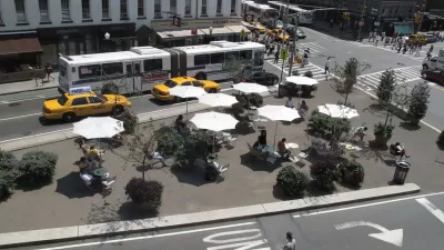
The New York Times' architecture critic, Michael Kimmelman, reviews a new exhibition exploring the history of the city's grid and streets.
"After all, before it could rise into the sky, Manhattan had to create the streets, avenues and blocks that support the skyscrapers. The grid was big government in action, a commercially minded boon to private development and, almost despite itself, a creative template. With 21st-century problems - environmental, technological, economic and social - now demanding aggressive and socially responsible leadership, the exhibition is a kind of object lesson.
Simeon De Witt, Gouverneur Morris and John Rutherfurd were entrusted with planning the city back in 1811. New York huddled mostly south of Canal Street, but it was booming, its population having tripled to 96,373 since 1790 thanks to the growing port. Civic boosters predicted that 400,000 people would live in the city by 1860. They turned out to be half-right. New York topped 800,000 before the Civil War.
The planners proposed a grid for this future city stretching northward from roughly Houston Street to 155th Street in the faraway heights of Harlem. It was in many respects a heartless plan. There were virtually no parks or plazas. The presumption was that people would gravitate east and west along the numbered streets to the rivers when they wanted open space and fresh air, and not spend lots of time moving north or south. That partly explains why there were only a dozen avenues."
The exhibit, The Greatest Grid: The Master Plan of Manhattan, 1811-2011, is currently showing at the Museum of the City of New York.
Thanks to Nate Berg
FULL STORY: The Grid at 200: Lines That Shaped Manhattan

Embracing the Future of City Streets
Streets will have to evolve, again.

A Grid Balancing Act for Vibrant, Varied, and Sustainable Places
An analysis of three essential attributes of urban grids reveals a preferred layout for the desired effect of a vibrant, active community.
New York's Streets Provide "Platform for Social Activism"
Justin Davidson ruminates on the great strides Janette Sadik-Khan and New York's Department of Transportation have made in reforming the city's streets. As much as they've accomplished, the transformation remains a work in progress.

Maui's Vacation Rental Debate Turns Ugly
Verbal attacks, misinformation campaigns and fistfights plague a high-stakes debate to convert thousands of vacation rentals into long-term housing.

Planetizen Federal Action Tracker
A weekly monitor of how Trump’s orders and actions are impacting planners and planning in America.

In Urban Planning, AI Prompting Could be the New Design Thinking
Creativity has long been key to great urban design. What if we see AI as our new creative partner?

King County Supportive Housing Program Offers Hope for Unhoused Residents
The county is taking a ‘Housing First’ approach that prioritizes getting people into housing, then offering wraparound supportive services.

Researchers Use AI to Get Clearer Picture of US Housing
Analysts are using artificial intelligence to supercharge their research by allowing them to comb through data faster. Though these AI tools can be error prone, they save time and housing researchers are optimistic about the future.

Making Shared Micromobility More Inclusive
Cities and shared mobility system operators can do more to include people with disabilities in planning and operations, per a new report.
Urban Design for Planners 1: Software Tools
This six-course series explores essential urban design concepts using open source software and equips planners with the tools they need to participate fully in the urban design process.
Planning for Universal Design
Learn the tools for implementing Universal Design in planning regulations.
planning NEXT
Appalachian Highlands Housing Partners
Mpact (founded as Rail~Volution)
City of Camden Redevelopment Agency
City of Astoria
City of Portland
City of Laramie