


Recognizing the inevitability of sea level rise and vulnerability of much of the Bay Area, the region has adopted the first climate adaptation rules in the nation. Building along the shores of S.F. Bay remains possible.
"New developments on the shores of San Francisco Bay won't be approved unless they offer economic or environmental benefits that outweigh the cost of protecting against rising seas, under rules adopted (Oct. 6) by the San Francisco Bay Conservation and Development Commission."
The new rules carry significant implications for a controversial 12,000-home, mixed-use development proposed on 1,435 acres of Cargill salt flats (where salt was harvested) along the Redwood City bay front known as the Redwood City Saltworks.
"We believe that the version adopted today removed the impediments to proactive collaboration on sea-level rise," DMB Associates (and Saltworks developer) Vice President David Smith said. "Our concerns with the earlier versions of the amendments were that they established prohibitions and presumptions that would have thwarted solutions."
At the same time, the new regulations appeared to please the main opponent to the Saltworks project, the environmental group Save the Bay.
From Save the Bay Blog: A Vote For Smart Policies: "With yesterday's vote, BCDC's Bay Plan now discourages new development in undeveloped areas vulnerable to rising seas, and encourages tidal wetland restoration instead. BCDC is now the first state agency implementing California's Climate Adaptation Strategy on sea level rise", blogged Executive Director David Lewis.
Thanks to Gita Dev
FULL STORY: Bay Area Adopts Historic Climate-Change Rules

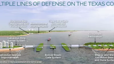
Revised Plans for Massive 'Ike Dike' Plan Revealed
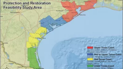
A $26.2 billion proposal to protect the coastal area around Galveston has evolved since its first iteration in 2018.
$31 Billion Hurricane Protection Plan Proposed for Texas
The U.S. Army Corps of Engineers has proposed a suite of coastal infrastructure projects—i.e., floodgates and seawalls—to shore up the coast of Texas against Hurricane- and sea level rise-aided water.
Managed Retreat from Sea Level Rise
Coastal communities are battling the near certain rising sea levels. As a result, many are faced with the choice to stay and rebuild their homes or begin the process of "managed retreat" away from vulnerable coastal areas.

Planetizen Federal Action Tracker
A weekly monitor of how Trump’s orders and actions are impacting planners and planning in America.

Maui's Vacation Rental Debate Turns Ugly
Verbal attacks, misinformation campaigns and fistfights plague a high-stakes debate to convert thousands of vacation rentals into long-term housing.

San Francisco Suspends Traffic Calming Amidst Record Deaths
Citing “a challenging fiscal landscape,” the city will cease the program on the heels of 42 traffic deaths, including 24 pedestrians.

Amtrak Rolls Out New Orleans to Alabama “Mardi Gras” Train
The new service will operate morning and evening departures between Mobile and New Orleans.

The Subversive Car-Free Guide to Trump's Great American Road Trip
Car-free ways to access Chicagoland’s best tourist attractions.

San Antonio and Austin are Fusing Into one Massive Megaregion
The region spanning the two central Texas cities is growing fast, posing challenges for local infrastructure and water supplies.
Urban Design for Planners 1: Software Tools
This six-course series explores essential urban design concepts using open source software and equips planners with the tools they need to participate fully in the urban design process.
Planning for Universal Design
Learn the tools for implementing Universal Design in planning regulations.
Heyer Gruel & Associates PA
JM Goldson LLC
Custer County Colorado
City of Camden Redevelopment Agency
City of Astoria
Transportation Research & Education Center (TREC) at Portland State University
Jefferson Parish Government
Camden Redevelopment Agency
City of Claremont