


As cities in developing countries expand, is smart growth the right approach? The conclusions of a new report by the Lincoln Institute of Land Policy may surprise you.
It was a different time when Daniel Burnham famously suggested, "make no little plans." But today, as rapidly growing cities in the developing world anticipate a great surge of urban population, planners really do need to think big.
Over half the world's current population lives in cities, including many millions in informal settlements. Demographic forecasts indicate that the world's urban population will double from 3 billion in 2000 to 6 billion in 2050, with nearly all urban growth occurring in developing countries. While the urban population in these nations doubles between 2000 and 2030, the built-up area of their cities can be expected to triple. This is clearly a mandate for preparation and planning.
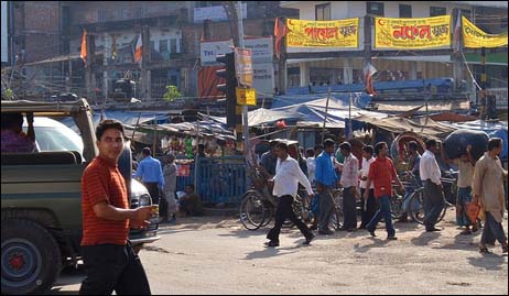
Our most recent Policy Focus Report, Making Room for a Planet of Cities, launched at an event last month hosted by the Cities Alliance and the World Bank in Washington, suggests that key components of such planning in developing countries include generous metropolitan limits, an arterial grid of streets spaced one kilometer apart that can support transit, and selective protection of open space. The goals of densification, infill, and containment may be generally appropriate for U.S. cities, but not for cities in the developing world where average urban population densities are over four times higher than in the U.S. A lack of realistic preparations for urban expansion there will result in land supply bottlenecks putting residential land out of reach for the urban poor as well as in massive informal and illegal settlements with little or no transport, water, or sanitation infrastructure.
The need for a new paradigm is informed in part by looking at how cities worldwide have expanded over time. Our research team, led by visiting scholar Shlomo "Solly" Angel, lead author of the report, looked at four data sets: satellite images from 1990 and 2000 for a sample of 120 cities having over 100,000 people ; geo-coded census tracts in 20 U.S. cities from 1910 to 2000; historical maps documenting how a global sample of 30 cities expanded from 1800 to 2000; and satellite images of urban land cover for over 3,600 cities in 2000.
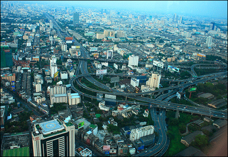
The team looked at five key attributes – urban land cover, density (population in relation to built-up area), centrality (population share near the city center), fragmentation (the amount of open space within cities), and compactness. They found that average densities declined as population and wealth grew, not just in the U.S., but worldwide. Reviewing the historic expansion of cities showed that 28 of the 30 sampled cities increased their area 16-fold during the 20th century. Bangkok, for example, increased its urbanized area 16-fold from 1944 to 2002. Spatial expansion outpaced population growth in all of the data sets but not in all cities: Los Angeles is a notable exception where densities have been slowly increasing in recent decades, making it now one of the densest metropolitan area in the U.S.
The population and area measures produce consistent urban built-up area average densities that range in the sample of 120 global cities from 555 persons per hectare in Dhaka, Bangladesh to only 15.7 in Tacoma, Washington. Average densities in urban built-up areas vary systematically across country groups, ranging from 25 persons per hectare in land-rich developed countries (United States, Canada, and Australia); to 50 in other developed countries (Europe and Japan); to 130 in developing countries-a level that exceeds average urban densities observed in the U.S. 100 years ago. Analysis of built-up area densities across cities supports the predictions of urban theory: for example, higher incomes and land availability are associated with lower densities; and larger city populations are associated with higher densities.
This is not to suggest that future cities in the developing world should foster development at low densities such as those in the U.S., nor that higher densities should not be encouraged in cities such as Tacoma. Angel's point is that the magnitude of growth expected in high-density places like Mumbai requires a different approach.
The history of urban planning suggests far-reaching preparations for urban expansion, Angel points out. The New York Commissioners Plan of 1811 extended the street grid northward from Lower Manhattan covering the entire island – all of which came to be. Other examples include Barcelona's Ensanche plan of 1859; Singapore's open space planning of parks and recreation areas; and the transit-supporting grid of Toronto, home to the 3rd largest public transport system in North America.
Failure to plan for expansion is evident in congestion-plagued Bangkok, with its lack of arterial roads, in San Salvador where zoning regulations are ignored, and in Sao Paulo where there has been little effective protection of open space within municipal boundaries.
For the rapid and inevitable urban expansion in developing countries to lead to equitable, inclusive, and green growth requires a different approach to urban development. William Cobbett, manager of Cities Alliance, a global coalition of cities and their development partners housed at the World Bank, said the new paradigm suggested by Angel's research should challenge the current reflex in many cities in developing countries, which is to try to keep out the poor. It can provide an opportunity to have a game-changing debate about urbanization. Planning for future urban growth and introducing long-term scenarios can set the stage for an alternative to the Mike Davis vision of a Planet of Slums.
There is no doubt this is a daunting task, requiring elected officials to plan and make investments with payoffs far beyond election cycles. But in contrast to Burnham's time, we have much more information about the spatial structure of cities. Data from global information systems and new technologies for processing digital maps are facilitating the study of urban expansion on a global scale. The Lincoln Institute has posted all the data, images, and methodology from Angel's research on its Web site, at the Atlas of Urban Expansion. Let the data be our guide.
Gregory K. Ingram is president and chief executive officer of the Lincoln Institute of Land Policy in Cambridge, Mass.

Berkeley Approves ‘Middle Housing’ Ordinance
The city that invented single-family zoning is finally reckoning with its history of exclusion.

Connecticut Governor Vetoes Housing Bill
Gov. Lamont reversed his view on a controversial affordable housing bill that would have required municipalities to zone for set amounts of affordable housing to receive state funding.

More Apartments Are Being Built in Less-Dense Areas
Rising housing costs in urban cores and a demand for rental housing is driving more multifamily development to exurbs and small metros.

Planetizen Federal Action Tracker
A weekly monitor of how Trump’s orders and actions are impacting planners and planning in America.

Restaurant Patios Were a Pandemic Win — Why Were They so Hard to Keep?
Social distancing requirements and changes in travel patterns prompted cities to pilot new uses for street and sidewalk space. Then it got complicated.

Map: Where Senate Republicans Want to Sell Your Public Lands
For public land advocates, the Senate Republicans’ proposal to sell millions of acres of public land in the West is “the biggest fight of their careers.”

Maui's Vacation Rental Debate Turns Ugly
Verbal attacks, misinformation campaigns and fistfights plague a high-stakes debate to convert thousands of vacation rentals into long-term housing.

San Francisco Suspends Traffic Calming Amidst Record Deaths
Citing “a challenging fiscal landscape,” the city will cease the program on the heels of 42 traffic deaths, including 24 pedestrians.

California Homeless Arrests, Citations Spike After Ruling
An investigation reveals that anti-homeless actions increased up to 500% after Grants Pass v. Johnson — even in cities claiming no policy change.
Urban Design for Planners 1: Software Tools
This six-course series explores essential urban design concepts using open source software and equips planners with the tools they need to participate fully in the urban design process.
Planning for Universal Design
Learn the tools for implementing Universal Design in planning regulations.
Heyer Gruel & Associates PA
JM Goldson LLC
Custer County Colorado
City of Camden Redevelopment Agency
City of Astoria
Transportation Research & Education Center (TREC) at Portland State University
Camden Redevelopment Agency
City of Claremont
Municipality of Princeton (NJ)