


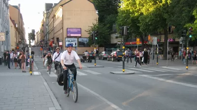
A hub of information and communications technology known as Kista Science City in Stockholm, Sweden, has focused on intelligent transportation to fuel its success.
In this interview from Next American City, Anette Scheibe, CEO, at Electrum Foundation and Kista Science City talks about the role of mobility in the city's development.
"Over time, Stockholm has been able to meet growth challenges by exploiting new land areas and through densification while successfully developing the transportation system to cope with growing needs. However, a few years ago we had critical levels of cars travelling into the downtown area on the main routes as the new ITS industry developed.
Since Stockholm is known as a city with extremely high internet penetration where everyone had early access to cell phones, and since it has a very large internationally recognized IT industry that is intensively engaged in research, it was natural to direct interest to this area. The city street department, Swedish Road Administration, and Stockholm Public Transport began collaborating in 2000 on a common vision for traffic solutions using IT and telecom, and by mid-decade a common portal for traffic information was available: www.trafiken.nu.
Kista Science City is a common city, business, research, and academic communication platform whose mission is to create forums for regional players. As an ICT cluster with more than 1,000 companies and strong growth, we believe that a new ITS focus area can contribute greatly to developing Stockholm's transportation system while generating new innovations and promoting new export solutions."
FULL STORY: An Interview with Anette Scheibe of Kista Science City in Stockholm


‘Stockholm Tree Pit’ Saves Dying Urban Trees
After noticing that two-thirds of its trees were dying, Stockholm developed a new planting method to protect trees surrounded by concrete.

Rent Control Buckling Under Market Pressure, Sweden Increases Development
A housing affordability case study, provided by the unique housing policies in the country of Sweden.
Sweden's 'One-Minute City' Reimagines the Street at a Hyper-Local Level
Rather than trying to meet all of a community's needs within a one-minute radius, Sweden's Street Moves pilot program gives residents the power to decide how street space gets used.

Montreal Mall to Become 6,000 Housing Units
Place Versailles will be transformed into a mixed-use complex over the next 25 years.

Planetizen Federal Action Tracker
A weekly monitor of how Trump’s orders and actions are impacting planners and planning in America.

DARTSpace Platform Streamlines Dallas TOD Application Process
The Dallas transit agency hopes a shorter permitting timeline will boost transit-oriented development around rail stations.

Study: 4% of Truckers Lack a Valid Commercial License
Over 56% of inspected trucks had other violations.

Chicago Judge Orders Thousands of Accessible Ped Signals
Only 3% of the city's crossing signals are currently accessible to blind pedestrians.

Philadelphia Swaps Car Lanes for Bikeways in Unanimous Vote
The project will transform one of the handful of streets responsible for 80% of the city’s major crashes.
Urban Design for Planners 1: Software Tools
This six-course series explores essential urban design concepts using open source software and equips planners with the tools they need to participate fully in the urban design process.
Planning for Universal Design
Learn the tools for implementing Universal Design in planning regulations.
City of Mt Shasta
City of Camden Redevelopment Agency
City of Astoria
Transportation Research & Education Center (TREC) at Portland State University
US High Speed Rail Association
City of Camden Redevelopment Agency
Municipality of Princeton (NJ)