


With the debut of the latest map of the Moscow Metro, TheCityFix's Jonna McKone takes a look at mass transit maps from across the globe and chats with mapmaker Cameron Booth.
According to McKone, "Moscow's new map took four years to develop, according to the design firm behind it, Art. Lebedev Studio. Its design is meant to be scalable to various sizes and complexity. A lot attention was paid to graphically representing the intersections of various transit lines.
Graphic designer Cameron Booth, who redesigned Washington, D.C.'s Metro map as a personal project (it's not publicly in use), answered a few of our questions about mapping. First off, Booth says transit maps are not really maps at all; they are 'diagrams that show connections between points and not the accurate geography of an area.' New York City's subway map is the major exception to this rule.
Thanks to Garrett Bradford
FULL STORY: Moscow Metro Map and Usability of Public Transportation Maps

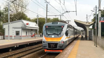
A New Suburban Rail System for Moscow
Two of a planned five new suburban rail routes, modeled on examples in Paris and Berlin, opened last week in Russia.
Wayfinding Symbols Across the World
Metro stations, train stations and streetcar systems have distinct ways of showing how to get from one area to another. TheCityFix's Jonna McKone looks at mass transit systems from Mexico City to Paris and the visual representations used in each one.
Friday Funny: Moscow Dogs Commute via Subway
Dogs in Moscow have learned to ride the subway to and from "work".

Planetizen Federal Action Tracker
A weekly monitor of how Trump’s orders and actions are impacting planners and planning in America.

Chicago’s Ghost Rails
Just beneath the surface of the modern city lie the remnants of its expansive early 20th-century streetcar system.

San Antonio and Austin are Fusing Into one Massive Megaregion
The region spanning the two central Texas cities is growing fast, posing challenges for local infrastructure and water supplies.

Since Zion's Shuttles Went Electric “The Smog is Gone”
Visitors to Zion National Park can enjoy the canyon via the nation’s first fully electric park shuttle system.

Trump Distributing DOT Safety Funds at 1/10 Rate of Biden
Funds for Safe Streets and other transportation safety and equity programs are being held up by administrative reviews and conflicts with the Trump administration’s priorities.

German Cities Subsidize Taxis for Women Amid Wave of Violence
Free or low-cost taxi rides can help women navigate cities more safely, but critics say the programs don't address the root causes of violence against women.
Urban Design for Planners 1: Software Tools
This six-course series explores essential urban design concepts using open source software and equips planners with the tools they need to participate fully in the urban design process.
Planning for Universal Design
Learn the tools for implementing Universal Design in planning regulations.
planning NEXT
Appalachian Highlands Housing Partners
Mpact (founded as Rail~Volution)
City of Camden Redevelopment Agency
City of Astoria
City of Portland
City of Laramie