


An architect and planner in India has proposed a plan to convert Delhi's storm drains into a network of walkways and passages.
"As far back as 700 years ago, the 18 major passageways (and their 15,000 sub-branches) provided a drainage system for excess rainwater, but unfortunately, they are now mostly filled with untreated sewage waste.
Rastogi says his Delhi Nullahs revitalization project (www.delhinullahs.org) will provide multiple environmental, cultural and transport benefits, breathing new life in the city of 17 million people. It would improve public health and restore ancient aquifers by installing small-scale equipment to treat Delhi's sewage at its source, relying on organic compounds like weeds and algae to clean the waste before it flows into the nullah network. It would boost activities related to everything from tourism to sports, as people explore the city's various monuments, museums, theaters and other cultural and historical assets along the River Yamuna. And finally, it would ease the city's traffic congestion by encouraging more commuters to bike and walk on paths along the waterways, which in turn, leads to increased physical activity, reduced air pollution, and other health and environmental advantages."
With more than 350 kilometers of storm drains, the proposed system could create an entirely new transportation network for the city.
FULL STORY: Turning Sewers into Sidewalks in Delhi


December Must-Reads: Top 10 Articles From Last Month
Making room for more housing, fixing broken sidewalks, and our favorite books of the year.
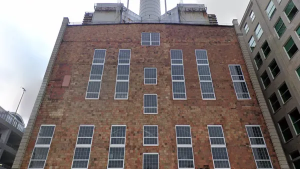
Defunct Pittsburgh Power Plant to Become Residential Tower
A decommissioned steam heat plant will be redeveloped into almost 100 affordable housing units.
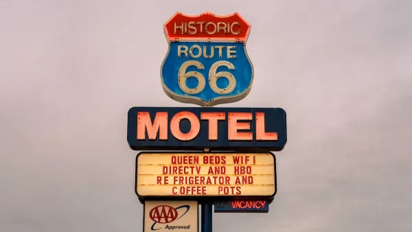
Albuquerque Route 66 Motels Become Affordable Housing
A $4 million city fund is incentivizing developers to breathe new life into derelict midcentury motels.

Maui's Vacation Rental Debate Turns Ugly
Verbal attacks, misinformation campaigns and fistfights plague a high-stakes debate to convert thousands of vacation rentals into long-term housing.

Planetizen Federal Action Tracker
A weekly monitor of how Trump’s orders and actions are impacting planners and planning in America.

San Francisco Suspends Traffic Calming Amidst Record Deaths
Citing “a challenging fiscal landscape,” the city will cease the program on the heels of 42 traffic deaths, including 24 pedestrians.

Defunct Pittsburgh Power Plant to Become Residential Tower
A decommissioned steam heat plant will be redeveloped into almost 100 affordable housing units.

Trump Prompts Restructuring of Transportation Research Board in “Unprecedented Overreach”
The TRB has eliminated more than half of its committees including those focused on climate, equity, and cities.

Amtrak Rolls Out New Orleans to Alabama “Mardi Gras” Train
The new service will operate morning and evening departures between Mobile and New Orleans.
Urban Design for Planners 1: Software Tools
This six-course series explores essential urban design concepts using open source software and equips planners with the tools they need to participate fully in the urban design process.
Planning for Universal Design
Learn the tools for implementing Universal Design in planning regulations.
Heyer Gruel & Associates PA
JM Goldson LLC
Custer County Colorado
City of Camden Redevelopment Agency
City of Astoria
Transportation Research & Education Center (TREC) at Portland State University
Jefferson Parish Government
Camden Redevelopment Agency
City of Claremont