


I frequently drive to an uncle’s house near the beach via the Garden State Parkway in New Jersey. For years, that drive required a very late Friday evening departure and a similarly late Sunday evening return trip to avoid the wicked stop-and-go that always mires t

I frequently drive to an uncle's house near the beach via the Garden State Parkway in New Jersey. For years, that drive required a very late Friday evening departure and a similarly late Sunday evening return trip to avoid the wicked stop-and-go that always mires the GSP. This year however, something positively different is happening that results in a lot less congestion at previously impossible times. I'm not quite sure what it is, so I'm going to guess for the sake of a blog post: map-based traffic reports.
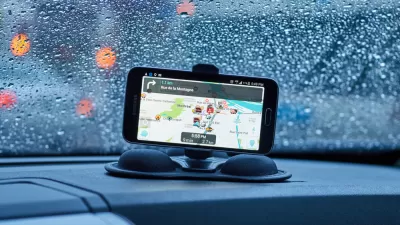
Here's my theory. My wife and I now regularly check the incredibly accurate Google maps traffic report Friday and Sunday afternoons. Major roadways are depicted with green, yellow, and red overlays representing free flow, slow, and stopped traffic, respectively. This free service is a simple click when looking at a Google map online, and is also available in various forms to other GPS systems and mobile phones. Each week we become more and more enamored with the accuracy of this information.
Friday, it seems, is a lost cause. The peak afternoon traffic combined with New Jersey's notorious "shore traffic" results in a sea of creeping cars that altogether destroys the chances of a smooth late afternoon drive south, even if you invited Moses with you for the drive. But on Sundays – when people have a bit more discretion on when to jump on the highway and head back home – the situation is quite different. By referring to the traffic mapping resources now available, it is entirely possible to confidently navigate through the previously standstill Parkway crunch times encountering only a few pockets of "red".
It's great to find such a rabbit hole, but I submit what is happening is a lot more than just maps of traffic patterns. Humans, as is our nature, tend to find a schedule and stay with it; once one capitulates to the possibility of Sunday afternoon traffic , departure time is more a matter of routine than logic. When people can preview traffic conditions before heading out however, they may be choosing to alter their departures in an attempt to select an easier travel window. I know this is happening, because after being dumbfounded that a lark departure last night at 7:15PM brought us home at 9:45PM (that's just 30 minutes longer than a 10PM-departure free-flow drive), I started thinking about our decision making process. We were planning to leave much later, but after reviewing the traffic information (in which we trust after weeks of testing), we took a chance on a much earlier departure.
I have written before about the convergence of mobility (technologies) and mobility (transportation), using the masochistically horrendous acronym ConMaM; the phenomenon I think I'm experiencing on the GSP may in fact be part of this revolution. What's so interesting about it is that discrete decisions are being made to not add more traffic to an already congested roadway (when it's red) and to put another car on the road when there is additional capacity (when it's green). These are purely selfish decisions, but they benefit society tremendously nonetheless. It's reflexive self-management at its best! For decades we've heard traffic engineers go on and on about autonomous car systems and Intelligent Traffic Systems (ITS), but here it seems that given the right input data, the ‘ol human brain is trumping anything we've been able to plug into a car's operating system.

Convergence of Mobility and Mobility (ConMaM)
One of the many glorious perks of being an engineer is that we are so bad at thinking up clever names for programs and tools that there's been an unabashed, universal concession by the general public to accept our use of horribly convoluted acronyms. My favorite transportation acronym sub-genre is the collection of traffic signal configurations that for no clear reason (other than because engineers are, deep down, fun people) have flown off on a winged tangent. The original intersection signal control which included pedestrian push buttons was “PEdestrian LIght CONtrolled”, close enough to be named “Pelican”. A “Pedestrian User-Friendly INtelligent crossing” alternative to the Pelican is named “Puffin”. Since a combined pedestrian/bicycle signal means two (
Flooded With Navigation App Users, a Town Closes Its Streets
Navigation apps like Waze often reroute drivers onto residential streets that would be quiet otherwise. With some residents unable to leave their driveways, the New Jersey borough of Leonia has taken an extreme measure against the problem.
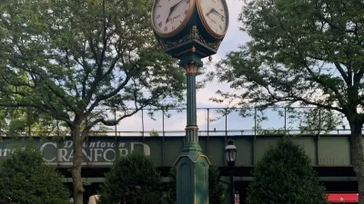
The Story of Eastman Clock Plaza in Downtown Cranford
How a small plaza in Cranford, New Jersey became a community beacon.

Planetizen Federal Action Tracker
A weekly monitor of how Trump’s orders and actions are impacting planners and planning in America.

Restaurant Patios Were a Pandemic Win — Why Were They so Hard to Keep?
Social distancing requirements and changes in travel patterns prompted cities to pilot new uses for street and sidewalk space. Then it got complicated.

Map: Where Senate Republicans Want to Sell Your Public Lands
For public land advocates, the Senate Republicans’ proposal to sell millions of acres of public land in the West is “the biggest fight of their careers.”

Maui's Vacation Rental Debate Turns Ugly
Verbal attacks, misinformation campaigns and fistfights plague a high-stakes debate to convert thousands of vacation rentals into long-term housing.

San Francisco Suspends Traffic Calming Amidst Record Deaths
Citing “a challenging fiscal landscape,” the city will cease the program on the heels of 42 traffic deaths, including 24 pedestrians.

California Homeless Arrests, Citations Spike After Ruling
An investigation reveals that anti-homeless actions increased up to 500% after Grants Pass v. Johnson — even in cities claiming no policy change.
Urban Design for Planners 1: Software Tools
This six-course series explores essential urban design concepts using open source software and equips planners with the tools they need to participate fully in the urban design process.
Planning for Universal Design
Learn the tools for implementing Universal Design in planning regulations.
Heyer Gruel & Associates PA
JM Goldson LLC
Custer County Colorado
City of Camden Redevelopment Agency
City of Astoria
Transportation Research & Education Center (TREC) at Portland State University
Camden Redevelopment Agency
City of Claremont
Municipality of Princeton (NJ)