


Flood maps redrawn by the Federal Emergency Management Agency are causing thousands of Southern California residents to buy mandatory flood insurance, even though they say flooding is rare and barely an issue.
"The federal government has informed property owners in more than 150 cities and unincorporated areas in Los Angeles, Orange, Ventura, Riverside and San Bernardino counties about the new requirement. Most live near rivers and creeks, below dams or in low- lying areas that are at greater risk of flooding than previously believed, according to maps developed by the Federal Emergency Management Agency.
Premiums range from $500 to more than $1,700 a year. Insurance is mandatory for anyone with a federally backed mortgage, and lenders will typically buy policies, sometimes at a higher cost, for property owners who fail to do so on their own. Fannie Mae and Freddie Mac own or guarantee more than half of all U.S. mortgages."
FEMA has been redrawing flood maps all over the country since 2003 in an effort to identify areas prone to risk during a 100-year storm event. Some Southern Californians affected by the new maps are planning to challenge the Agency's redrawing.
FULL STORY: Homeowners forced to buy flood insurance after FEMA redraws maps


FEMA Resilience Program Cuts Grant Funding
The Building Resilient Infrastructure and Communities program funded projects from flood prevention to power station upgrades.
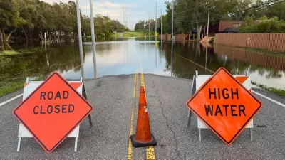
FEMA Suspends Flood Rebuilding Standard
The rule was designed to prevent the rebuilding of government-funded projects in areas prone to repeated floods.

Future Floods in Focus: Using AI and Physics to Visualize Disaster Risks
MIT researchers have developed a groundbreaking AI-powered tool that integrates physics-based models to generate realistic satellite images of future flooding, offering communities a powerful way to visualize and prepare for disasters.

Maui's Vacation Rental Debate Turns Ugly
Verbal attacks, misinformation campaigns and fistfights plague a high-stakes debate to convert thousands of vacation rentals into long-term housing.

Planetizen Federal Action Tracker
A weekly monitor of how Trump’s orders and actions are impacting planners and planning in America.

San Francisco Suspends Traffic Calming Amidst Record Deaths
Citing “a challenging fiscal landscape,” the city will cease the program on the heels of 42 traffic deaths, including 24 pedestrians.

Defunct Pittsburgh Power Plant to Become Residential Tower
A decommissioned steam heat plant will be redeveloped into almost 100 affordable housing units.

Trump Prompts Restructuring of Transportation Research Board in “Unprecedented Overreach”
The TRB has eliminated more than half of its committees including those focused on climate, equity, and cities.

Amtrak Rolls Out New Orleans to Alabama “Mardi Gras” Train
The new service will operate morning and evening departures between Mobile and New Orleans.
Urban Design for Planners 1: Software Tools
This six-course series explores essential urban design concepts using open source software and equips planners with the tools they need to participate fully in the urban design process.
Planning for Universal Design
Learn the tools for implementing Universal Design in planning regulations.
Heyer Gruel & Associates PA
JM Goldson LLC
Custer County Colorado
City of Camden Redevelopment Agency
City of Astoria
Transportation Research & Education Center (TREC) at Portland State University
Jefferson Parish Government
Camden Redevelopment Agency
City of Claremont