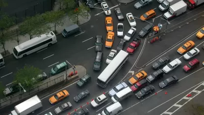
As New York City prepares to pedestrianize Times Square, New York Magazine profiles Transportation Commissioner Janette Sadik-Khan, who they call "equal parts Jane Jacobs and Robert Moses."
"This simple but dramatic act will amount to bypass surgery on the heart of New York. It will become the most visible component yet of Mayor Bloomberg's citywide attempt to make New York's streets calmer, greener, and safer. And it will establish the front lines of a growing movement to tilt the balance of asphalt power away from the automobile and toward cyclists and pedestrians."
"...You'd think that closing Broadway to traffic would be seen as a grand egalitarian gesture. Returning a public amenity like the street to the perambulating masses should be a source of democratic harmony. And yet it's not. Plans like these never are. Perhaps it's the sense of a centralized hidden hand at work. Or maybe it's the fact that the streets are the ultimate shared resource, giving everyone a proprietary feeling about them. But redrawing the map of the city invariably stokes suspicion and resentment, and doing so at its absolute nerve center is being read by some as an act of provocation.
Sadik-Khan has been at her job long enough to know that one does not rearrange traffic in midtown lightly, so she has grounded her Broadway plan on assiduous analysis and computer modeling of traffic flow. She has managed a sophisticated PR campaign that has paid off with support from both the Times and the Daily News, as well as the business-improvement districts.
But even though her models suggest that simplifying the three-way intersections will enhance circulation, she has yet to convince many of the players who use Times Square the most."
Thanks to Reconnecting America
FULL STORY: Honk, Honk, Aaah

Maui's Vacation Rental Debate Turns Ugly
Verbal attacks, misinformation campaigns and fistfights plague a high-stakes debate to convert thousands of vacation rentals into long-term housing.

Planetizen Federal Action Tracker
A weekly monitor of how Trump’s orders and actions are impacting planners and planning in America.

In Urban Planning, AI Prompting Could be the New Design Thinking
Creativity has long been key to great urban design. What if we see AI as our new creative partner?

Cal Fire Chatbot Fails to Answer Basic Questions
An AI chatbot designed to provide information about wildfires can’t answer questions about evacuation orders, among other problems.

What Happens if Trump Kills Section 8?
The Trump admin aims to slash federal rental aid by nearly half and shift distribution to states. Experts warn this could spike homelessness and destabilize communities nationwide.

Sean Duffy Targets Rainbow Crosswalks in Road Safety Efforts
Despite evidence that colorful crosswalks actually improve intersection safety — and the lack of almost any crosswalks at all on the nation’s most dangerous arterial roads — U.S. Transportation Secretary Duffy is calling on states to remove them.
Urban Design for Planners 1: Software Tools
This six-course series explores essential urban design concepts using open source software and equips planners with the tools they need to participate fully in the urban design process.
Planning for Universal Design
Learn the tools for implementing Universal Design in planning regulations.
Appalachian Highlands Housing Partners
Gallatin County Department of Planning & Community Development
Heyer Gruel & Associates PA
Mpact (founded as Rail~Volution)
City of Camden Redevelopment Agency
City of Astoria
City of Portland
City of Laramie


