


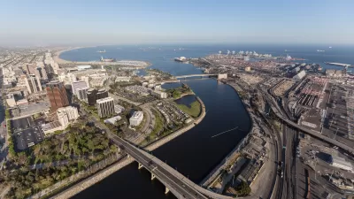
The Mississippi and Missouri rivers were once dramatically wider, but a century of re-engineering has constricted their courses, making "flood magnification" inevitable.
"The floodwaters are starting to ebb in the swollen Mississippi, which in the past few weeks has seen its worst flooding in 15 years. Since May, at least 24 people have died from the torrential rains and flooding, more than 38,000 people have evacuated their homes and an estimated 5 million acres of corn and soybean have been waterlogged. But as the great mop-up begins, some scientists contend this is one natural disaster that is by no means just natural: It is the dramatic result of more than 100 years of narrowing and constricting the river.
[Scientists] charge that structures built by the U.S. Army Corps of Engineers to aid the shipping industry are contributing to the flooding. They're calling for the National Academy of Sciences to have oversight over Army Corps river projects, and for the federal agency to refrain from building structures that exacerbate the floods.
Even before the recent deluge, scientists sounded the alarm. Back in March, weeks before the floods occurred, Criss, Pinter and professor Timothy Kusky of St. Louis University sent a letter to the commander for the St. Louis district of the Army Corps of Engineers, critiquing the new structures that the agency puts into the Mississippi and Missouri to make it easier for large barges to navigate the area.
The dramatic reengineering of the Mississippi through levees and other structures has been going on for over 100 years. Way back in 1837 when then-Lt. Robert E. Lee of the Army Corps of Engineers mapped the Mississippi at St. Louis, it was almost 4,000 feet wide. Today it's just 1,500 feet wide at St. Louis. The Missouri river has also been drastically shrunk.
Now that the river can't naturally spread out on its flood plain or meander, the extra water under flooding conditions has nowhere to go."
FULL STORY: A deluge waiting to happen


More Passenger Rail Coming to Montana
Planning is underway to restore a 45-year-defunct regional passenger rail line connecting southern Montana to Billings and Amtrak’s east-west Empire Builder line from Seattle to Chicago.

Elevating the ‘Small Stuff’ in Urban Design
Chuck Wolfe recaps arguments in favor of increased attention to incidentals — from benches to bollards — in urban development practices.
Los Angeles County Initiates Effort to Advance Equity in Infrastructure
L.A. County Public Works has launched an initiative to center equity in all of its processes, programming, and services as it plans, designs, builds, and maintains modern infrastructure that uplifts all communities of the county.

Planetizen Federal Action Tracker
A weekly monitor of how Trump’s orders and actions are impacting planners and planning in America.

Restaurant Patios Were a Pandemic Win — Why Were They so Hard to Keep?
Social distancing requirements and changes in travel patterns prompted cities to pilot new uses for street and sidewalk space. Then it got complicated.

Map: Where Senate Republicans Want to Sell Your Public Lands
For public land advocates, the Senate Republicans’ proposal to sell millions of acres of public land in the West is “the biggest fight of their careers.”

Maui's Vacation Rental Debate Turns Ugly
Verbal attacks, misinformation campaigns and fistfights plague a high-stakes debate to convert thousands of vacation rentals into long-term housing.

San Francisco Suspends Traffic Calming Amidst Record Deaths
Citing “a challenging fiscal landscape,” the city will cease the program on the heels of 42 traffic deaths, including 24 pedestrians.

California Homeless Arrests, Citations Spike After Ruling
An investigation reveals that anti-homeless actions increased up to 500% after Grants Pass v. Johnson — even in cities claiming no policy change.
Urban Design for Planners 1: Software Tools
This six-course series explores essential urban design concepts using open source software and equips planners with the tools they need to participate fully in the urban design process.
Planning for Universal Design
Learn the tools for implementing Universal Design in planning regulations.
Heyer Gruel & Associates PA
JM Goldson LLC
Custer County Colorado
City of Camden Redevelopment Agency
City of Astoria
Transportation Research & Education Center (TREC) at Portland State University
Camden Redevelopment Agency
City of Claremont
Municipality of Princeton (NJ)