


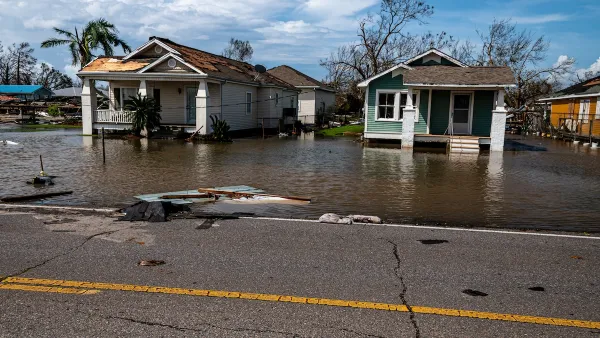
With sea levels rising, once-a-century floods may become once-in-20-years events. One solution: huge storm-surge barriers.
By 2050, stronger storms and rising sea levels may make the flood that previously hitNew York once every 100 years a once-in-20-years event, according to GISS. With a possible three-foot sea level rise by 2100, flooding could occur every four years. "Our old ideas about climate may have to change," he says. "We need to be open to all possibilities."
"Rather than individually shoring up the city's many vulnerabilities, the better solution is to use the region's topography, say engineer Douglas Hill and Malcolm Bowman, head of the Storm Surge Research Group at Stony Brook University. Three barriers placed at strategic "choke points" -- the Verrazano Narrows, Throgs Neck, and the Arthur Kill - would protect all of Manhattan and half the entire flood-prone area, they say."
Thanks to Ashwani Vasishth
FULL STORY: How to keep New York afloat


Planetizen Federal Action Tracker
A weekly monitor of how Trump’s orders and actions are impacting planners and planning in America.

Vehicle-related Deaths Drop 29% in Richmond, VA
The seventh year of the city's Vision Zero strategy also cut the number of people killed in alcohol-related crashes by half.
As Trump Phases Out FEMA, Is It Time to Flee the Floodplains?
With less federal funding available for disaster relief efforts, the need to relocate at-risk communities is more urgent than ever.

Raleigh Pilots App-Based Feedback Program for Accessible Parking
The city is using the program to collect real-time information about accessibility issues and correct them quickly.

Texas Safety Advocates Raise Alarm in Advance of Tesla Robotaxi Launch
The company plans to deploy self-driving taxis in Austin with no oversight from state or local transportation agencies.

How to Fund SF’s Muni Without Cutting Service
Three solutions for bridging the San Francisco transit agency’s budget gap without reducing service for transit-dependent riders.
Urban Design for Planners 1: Software Tools
This six-course series explores essential urban design concepts using open source software and equips planners with the tools they need to participate fully in the urban design process.
Planning for Universal Design
Learn the tools for implementing Universal Design in planning regulations.
Borough of Carlisle
Smith Gee Studio
City of Camden Redevelopment Agency
City of Astoria
Transportation Research & Education Center (TREC) at Portland State University
City of Camden Redevelopment Agency
Municipality of Princeton (NJ)