Exurban counties exemplify the shortcomings of defining rural at the county level.


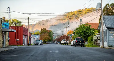
Chester County, South Carolina, is caught in a geographic contradiction. Situated in upstate South Carolina’s hilly piedmont region, Chester County is home to about 33,000 residents and contains a section of Sumter National Forest.
Although Chester is considered largely rural according to some definitions, it falls into the urban bucket in other categorization systems. As a growing suburb of the city of Charlotte, North Carolina, Chester is a metropolitan, or urban, county according to the Office of Management and Budget (OMB), which is the county-level system we typically use to define rural at the Daily Yonder.
But according to the Census’s block-level definition of rural, 73% of Chester’s population lives outside of urban blocks, the smallest geography used by the Census. Despite its metropolitan classification in most of our data analyses, much of Chester County still experiences challenges related to accessing resources that are common in lower-income rural communities.
Chester County has a shortage of primary care doctors, for example, and parts of the county show shortages in dental care and mental health access as well. These shortage areas come from the Health Resources and Services Administration (HRSA), which categorizes communities into Health Professional Shortage Areas (HPSAs) if they meet the following criteria:
(1) The area is a rational area for the delivery of health services.
(2) The area meets certain thresholds for a low provider / resident ratio.
(3) Health professionals in the area are overutilized or inaccessible.
(You can download the Technical Documentation for more information here.)
Chester County also has a poverty rate of 19%, six percentage points higher than South Carolina’s rate and 20% of households don’t have access to broadband internet, compared to 13% of the state’s households at large.
Chester County isn’t unique. In April, the Daily Yonder gained support from St. David’s Foundation, an organization that works to advance health equity in Central Texas, to produce equity-focused reporting on the relationship between civic capacity and community health in the exurban counties surrounding Austin, specifically Bastrop and Caldwell counties.
Chester, Bastrop and Caldwell counties belong to 588 other counties nationwide that are metropolitan at the county level, but where a third or more of the population lives in rural-defined census blocks. I am referring to these 588 counties as exurban, though my working definition is somewhat arbitrary because there is no official definition of the term.
The following map shows rural, urban and exurban counties.

I want to define these geographies to examine some of these communities that are frequently excluded in rural statistical analysis, but where environmental, health and civic challenges go underreported. These are communities that typically fall outside of our binary metro / nonmetro system.
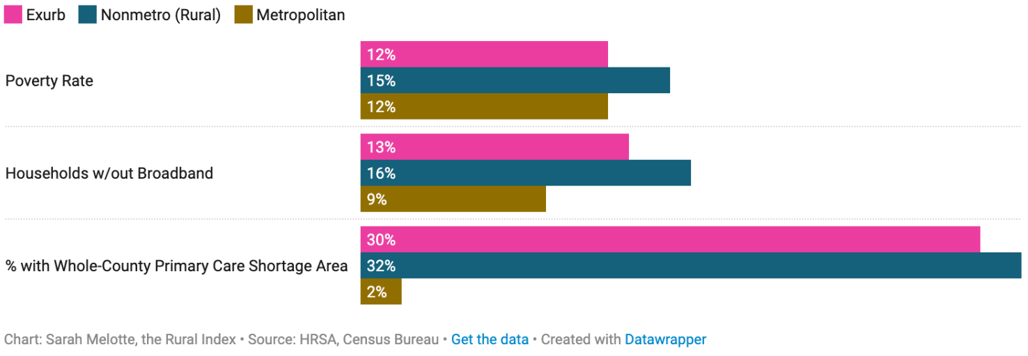
When we break out these communities from the metro / nonmetro system, we see differences between them on several metrics. These exurban counties tend to look more similar to rural counties when it comes to primary care, dental and mental healthcare shortages. The same goes for access to broadband. Poverty rates in exurban counties, however, are more similar to the overall metropolitan rate of approximately 12%.
Since we’re on the topic of data complexity and how rigid systems obscure truth on the ground, I feel the need to share something I think about frequently. Just like county-level definitions can mis-categorize rural communities, they tend to obscure poverty and access to resource challenges in urban areas as well. But because cities are by nature more population-dense, county-level categorization systems sometimes miss pockets of poverty that hide at a larger scale.
Take Travis County, Texas, for instance, where Austin is the county seat. The poverty rate in Travis County is 11%. But if you were to zoom into specific neighborhoods, you’d find a much more complex picture. Parts of the Austin metro area are seeing growing food insecurity and lower household incomes compared to the city at large, but my usual method of comparing rural to urban demographics would miss that fact.
All of this is to say that I have not nailed down a perfect way to map healthcare and resource challenges. Any categorization system necessarily obscures truths on the ground. That’s the nature of making generalizations. Any effort to describe phenomena at large scales is going to fall short of capturing complexity, but it is a necessary evil in data journalism, and one that I wrestle with every day.
Keep this shortcoming of my method in mind as we move forward in our comparative analysis.
The following map shows exurban counties where either the entire county or a portion of the county have primary care shortage areas. Shortage areas tend to be concentrated in states with a lot of dense metro areas and surrounding rural populations. In states where a very large portion of the population is rural, like Wyoming and Nevada, there are fewer exurban communities.

Bastrop County, Texas, an exurban county adjacent to Austin, is a primary care shortage area, and so is neighboring Caldwell County. Portions of both of these counties also have dental and mental health care shortage areas, according to the HRSA dataset.
A greater share of residents in Bastrop and Caldwell counties also lack access to high-speed internet compared to Texas at large. In Bastrop County, 14% of residents lack broadband, compared to 10% of Texans generally. Twelve percent of Caldwell County residents lack broadband. In neighboring Travis County, meanwhile, that number was only 7%.
Method Note: The Census and the Office of Management and Budget (OMB) don’t define rural. Instead, they identify urban (in the Census) and metropolitan (in the OMB) areas. At the Daily Yonder, we consider rural to be geographies that lie outside of these urban or metropolitan boundaries.
The percentage of rural residents in each county comes from tabulating the percentage of the population that lives outside of Census-defined urban areas. You can read more about how they define urbanity here.
—
This article first appeared on The Daily Yonder and is republished here under a Creative Commons Attribution-NoDerivatives 4.0 International License.

Study: Urban US Residents Have Higher Life Expectancy Than Rural Americans
A combination of economic and social factors leads to higher rates of disease and reduced access to healthcare for many rural residents.
What Central Florida's Population Growth Reveals About U.S. Real Estate Trends
Big trends—a geographic shift back to the suburban and exurban areas and a "silver tsunami"—are apparent in population figures for two Florida locations.

California Growth Shows an Exurban Pattern
The "back to the city" narrative might make for good headlines, but an analysis of California's growth patterns tell a different story. Take San Diego County as an example.

Planetizen Federal Action Tracker
A weekly monitor of how Trump’s orders and actions are impacting planners and planning in America.
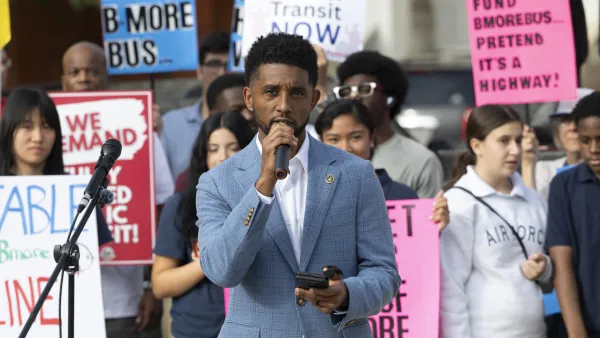
‘Going backwards:’ Baltimore mayor, students rally against state's transit funding plan
Maryland's proposed six-year plan provides no funding for Baltimore’s BMORE bus program and reduces its road maintenance funding.

Detroit to transform waterfront with $2.2 billion investment
Developers will convert about 18 acres of unused parking lot space into civic spaces.

After $600,000 wasted, CA high-speed rail board limits CEO’s power
Ian Choudri will no longer be able to sign, change or manage contracts.

Lithium mines leech water from surrounding communities. Soon, they’ll run dry
Researchers concluded that most lithium mines won't have enough water to meet industry demands by 2050.

El Niño takes lives, infrastructure as U.S. storm systems prove ill-prepared
About two-thirds of America's culverts are in states with outdated design standards.

FREE Course: Walkable City 1: Why Walkability?
After describing his path towards focusing on walkability as the essence of good planning, Jeff Speck marches through his five principal reasons for making more walkable places.
Reinventing Malls: Planning Alchemy—Turning Gray Fields Into Gold
The course focuses on the opportunities and imperatives that shape reinvention of mall sites.

One Hundred Miles
County of Mendocino
planning NEXT
The Architects Foundation
University of Cincinnati Online
Montrose County
Northern Illinois Transit Authority (NITA)
The Pocatello Development Authority

