


University of Hawaiʻi researchers are using advanced remote sensing technologies to protect cultural resources in five Hawaiʻi national parks from climate change impacts while training students in cutting-edge environmental science techniques.
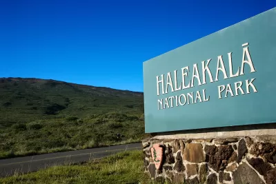
University of Hawaiʻi researchers are leading an innovative project to protect five coastal national parks in Hawaiʻi from climate change threats such as sea level rise, storm surges, flooding, and erosion. The initiative, funded by a $1.15 million National Park Service (NPS) grant, focuses on cultural resource preservation using high-resolution digital tools. Professors Ryan Perroy from UH Hilo and Seth Quintus from UH Mānoa are co-principal investigators, leveraging advanced technologies to document and assess cultural sites across parks like Haleakalā, Kalaupapa, and Puʻuhonua o Honaunau. The study aims to enhance resilience modeling and adaptation planning to safeguard these critical heritage sites.
The research team employs cutting-edge remote sensing techniques, including drone and helicopter-mounted imaging, to collect precise data from extensive and hard-to-reach areas. These tools allow for efficient surveying of nearshore and flood-prone regions, producing high-resolution digital documentation for resource monitoring. The project builds on previous documentation efforts by the NPS and will support the development of condition assessment protocols. Perroy, an expert in aerial robotics and geospatial analysis, oversees the spatial data analysis lab at UH Hilo, which plays a pivotal role in addressing environmental challenges in Hawaiʻi and the Pacific.
In addition to resource preservation, the project emphasizes education and training by involving four students—two each from UH Hilo and UH Mānoa. These students will gain hands-on experience in advanced remote sensing, including data collection, processing, and analysis. The initiative not only contributes to cultural resource protection but also prepares future experts in environmental science and geospatial technologies, equipping them to tackle the impacts of climate change on vulnerable ecosystems and heritage sites.
FULL STORY: UH researchers help protect 5 Hawaiʻi national parks

America’s 10 ‘Greenest’ Cities
A new analysis ranks cities based on their environmental quality, energy consumption and production, transportation, density, and other factors.
Op-Ed: Congress Passes Public Lands Bill, Ducks Harder Questions
The Natural Resources Management Act enjoyed bipartisan support in both houses of Congress. But it left out contentious issues like wildfires, greenhouse gas emissions, and protecting wildlife corridors.
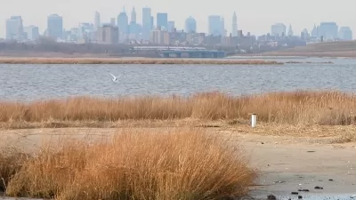
Jamaica Bay: Wilderness in the City
Created so people could "experience nature in the midst of crowds," New York's Jamaica Bay National Wildlife Refuge embodies the characteristics of all modern national parks: abundant, welcoming, and threatened.

Planetizen Federal Action Tracker
A weekly monitor of how Trump’s orders and actions are impacting planners and planning in America.

Chicago’s Ghost Rails
Just beneath the surface of the modern city lie the remnants of its expansive early 20th-century streetcar system.

San Antonio and Austin are Fusing Into one Massive Megaregion
The region spanning the two central Texas cities is growing fast, posing challenges for local infrastructure and water supplies.

Since Zion's Shuttles Went Electric “The Smog is Gone”
Visitors to Zion National Park can enjoy the canyon via the nation’s first fully electric park shuttle system.

Trump Distributing DOT Safety Funds at 1/10 Rate of Biden
Funds for Safe Streets and other transportation safety and equity programs are being held up by administrative reviews and conflicts with the Trump administration’s priorities.

German Cities Subsidize Taxis for Women Amid Wave of Violence
Free or low-cost taxi rides can help women navigate cities more safely, but critics say the programs don't address the root causes of violence against women.
Urban Design for Planners 1: Software Tools
This six-course series explores essential urban design concepts using open source software and equips planners with the tools they need to participate fully in the urban design process.
Planning for Universal Design
Learn the tools for implementing Universal Design in planning regulations.
planning NEXT
Appalachian Highlands Housing Partners
Mpact (founded as Rail~Volution)
City of Camden Redevelopment Agency
City of Astoria
City of Portland
City of Laramie