


The city’s plan includes parks, entertainment pavilions, commercial space, sports fields, and other facilities over 30 acres of deck parks spanning a sunken Interstate 35.
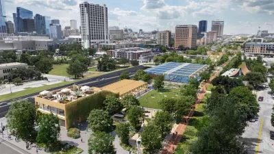
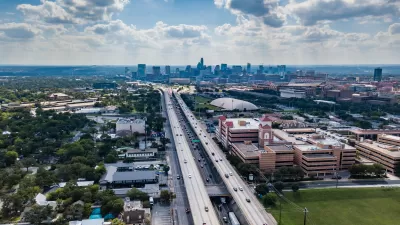
Newly revealed plans show Austin’s finalized vision for capping Interstate 35 after the Texas Department of Transportation lowers the main lanes below street level to accommodate deck parks.
Nathan Bernier describes the proposal, which includes a series of ‘caps and stitches,’ for KUT News. “Caps are more than 300 feet wide, and require advanced ventilation and fire suppression technology for the lanes below. Stitches are essentially caps that are less than 300 feet wide and don't require as much equipment.”
But don’t expect to walk around on top of I-35 anytime soon: “While the first cap could open as soon as 2032, a child born today would have graduated college by the time the plans depicted below are fully constructed,” Bernier notes. (See the source article for images.) Funding for the full project also remains unclear, although it has received some federal grants.
Bernier provides a walkthrough of the plans, outlining the key elements of each portion of the project. “Austin has to prove to TxDOT that it's serious about the capping project. The city must pay the state $19 million by the end of the year to finish engineering designs for the base caps. Local officials must also present TxDOT with a funding plan that shows how the city will pay for everything.”
FULL STORY: Austin reveals most detailed plans yet for parks over I-35


Austin in Race Against Time to Secure Freeway Cap Funding
With a major freeway expansion project looming, the Texas capital is seeking federal funding to build several freeway ‘decks’ downtown.
Letter Reveals Changes to I-35 Expansion Plan in Austin
In addition to new HOV lanes and a proposed boardwalk, TxDOT agreed to engineer the freeway for caps in some areas, but the city would have to fund their construction.
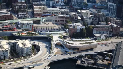
Seattle’s New Overlook Walk Offers Ample Park Space Near Pike Place Market
The elevated park and event space replaces part of the demolished Alaskan Way Viaduct, connecting the city’s famous Pike Place Market to the waterfront.

Planetizen Federal Action Tracker
A weekly monitor of how Trump’s orders and actions are impacting planners and planning in America.

Congressman Proposes Bill to Rename DC Metro “Trump Train”
The Make Autorail Great Again Act would withhold federal funding to the system until the Washington Metropolitan Area Transit Authority (WMATA), rebrands as the Washington Metropolitan Authority for Greater Access (WMAGA).

The Simple Legislative Tool Transforming Vacant Downtowns
In California, Michigan and Georgia, an easy win is bringing dollars — and delight — back to city centers.

Supporting Cycling Takes More Than Just Bike Lanes
Safe, protected bike lanes are a key part of a city’s bike infrastructure — but secure parking, e-bike charging, and other amenities can also influence people’s shift to cycling.

Judge Blocks Anti-DEI Rules for Transportation, Housing Grants
A second injunction blocks the Trump administration from enforcing new regulations for federal funding.

Unhoused People in San Jose Could Face Arrest if They Refuse Shelter
A policy proposed by the city’s mayor would give law enforcement the option to arrest homeless residents if they refuse three offers of housing.
Urban Design for Planners 1: Software Tools
This six-course series explores essential urban design concepts using open source software and equips planners with the tools they need to participate fully in the urban design process.
Planning for Universal Design
Learn the tools for implementing Universal Design in planning regulations.
Smith Gee Studio
City of Charlotte
City of Camden Redevelopment Agency
City of Astoria
Transportation Research & Education Center (TREC) at Portland State University
US High Speed Rail Association
City of Camden Redevelopment Agency
Municipality of Princeton (NJ)