


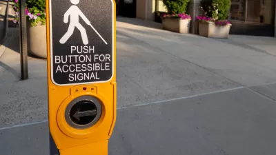
Under the new rule, state and local governments would be required to adhere to a specific set of accessibility guidelines when designing, constructing, or altering pedestrian facilities in the public right-of-way, including transit stops.

The U.S. Department of Transportation has published a proposed rule to amend its rules implementing the transportation provisions under the Americans with Disabilities Act, according to an article in Smart Cities Dive. The rule would adopt pedestrian accessibility guidelines issued last year by the Architectural and Transportation Barriers Compliance Board into the department’s ADA regulations, making them a basis for enforcing standards. This is a big change because, according to Smart Cities Dive senior reporter Dan Zukowski, “Until now, state and local governments have been left to determine how to comply with the ADA’s mandate to make public pedestrian transportation facilities accessible to people with physical or mental impairments or a history of impairment.”
If adopted, the standards would apply to all new-construction or alterations to state and local government pedestrian facilities in the public right-of-way, including sidewalks, crosswalks, pedestrian traffic signals, transit stops, and on-street parking. The article calls out in particular the DOT’s concerns and requests for comment about the location of transit stops that overlap with vehicular lanes, including bicycle lanes, and put people with vision impairments or who use mobility aids like wheelchairs at risk of being struck. This is a frequent criticism by the disability community of “floating” bus stops that are separated from the curb by a bike lane. Public comment is open until September 23, 2024.
FULL STORY: US DOT proposes rule on pedestrian accessibility standards


Baltimore to Allocate $44 Million to ADA Compliance
The plan is the result of a lawsuit brought by residents who say the city has failed to maintain safe, accessible sidewalks and streets for people with disabilities.

Understanding Accessibility in the Public Right-of-Way
A ‘best practices’ manual guides accessibility on streets and sidewalks, but remains legally unenforceable.
New Guidelines Bring Clarity to Accessibility Requirements
The new rules could help bridge the gaps in accessibility infrastructure and ADA compliance, making roads and sidewalks safer for everyone.

Planetizen Federal Action Tracker
A weekly monitor of how Trump’s orders and actions are impacting planners and planning in America.

DARTSpace Platform Streamlines Dallas TOD Application Process
The Dallas transit agency hopes a shorter permitting timeline will boost transit-oriented development around rail stations.

Four Reasons Urban Planners Can’t Ignore AI
It’s no longer a question of whether AI will shape planning, but how. That how is up to us.

Supreme Court Ruling in Pipeline Case Guts Federal Environmental Law
The decision limits the scope of a federal law that mandates extensive environmental impact reviews of energy, infrastructure, and transportation projects.

Texas State Bills to Defund Dallas Transit Die
DART would have seen a 30% service cut, $230M annual losses had the bills survived.

Bikeshare for the Win: Team Pedals to London Cricket Match, Beats Rivals Stuck in Traffic
While their opponents sat in gridlock, England's national cricket team hopped Lime bikes, riding to a 3-0 victory.
Urban Design for Planners 1: Software Tools
This six-course series explores essential urban design concepts using open source software and equips planners with the tools they need to participate fully in the urban design process.
Planning for Universal Design
Learn the tools for implementing Universal Design in planning regulations.
City of Mt Shasta
City of Camden Redevelopment Agency
City of Astoria
Transportation Research & Education Center (TREC) at Portland State University
US High Speed Rail Association
City of Camden Redevelopment Agency
Municipality of Princeton (NJ)