


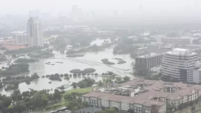
Texas researchers are testing the tool in Galveston, where Hurricane Ike caused billions in damage in 2008.

Researchers in Texas are testing out 3D modeling technology to predict potential hurricane damage and assess the effectiveness of proposed mitigation measures, reports Alyson Chapman in Route Fifty. The team used residential buildings to map out potential flood risk and understand the potential impacts of a flood mitigation project, the ‘Ike Dike,’ designed to shield Galveston from future storms.
An advantage of 3D visualization over other damage modeling methods is that it allows researchers to model specific buildings, accounting for basements, back entrances, and windows. By identifying a residential building’s first-floor elevation level, researchers can predict the physical and financial damage that a hurricane will cause to the specific building.
Expanding the tool to commercial and public buildings can help local officials develop hurricane preparedness plans. Additionally, “As real-time weather forecasts are implemented into the models, researchers may be able to determine when evacuation is necessary and use this data to alert residents.”
FULL STORY: 3D visualization predicts hurricane damage before it happens

Texas Flood Plan Shows One in Six Residents Live With Flood Risk
One-fourth of the state’s land falls within 100-year or 500-year floodplains.

New York Flood Control Plan Takes Lessons From the Dutch
The Netherlands has a long history of flood mitigation. U.S. cities, threatened by coastal flooding and erosion, are taking note.

East River Floodgates Rising in NYC
A tour of new infrastructure designed to protect the city’s East Side from catastrophic flooding.

Planetizen Federal Action Tracker
A weekly monitor of how Trump’s orders and actions are impacting planners and planning in America.

Congressman Proposes Bill to Rename DC Metro “Trump Train”
The Make Autorail Great Again Act would withhold federal funding to the system until the Washington Metropolitan Area Transit Authority (WMATA), rebrands as the Washington Metropolitan Authority for Greater Access (WMAGA).

The Simple Legislative Tool Transforming Vacant Downtowns
In California, Michigan and Georgia, an easy win is bringing dollars — and delight — back to city centers.

The States Losing Rural Delivery Rooms at an Alarming Pace
In some states, as few as 9% of rural hospitals still deliver babies. As a result, rising pre-term births, no adequate pre-term care and harrowing close calls are a growing reality.

The Small South Asian Republic Going all in on EVs
Thanks to one simple policy change less than five years ago, 65% of new cars in this Himalayan country are now electric.

DC Backpedals on Bike Lane Protection, Swaps Barriers for Paint
Citing aesthetic concerns, the city is removing the concrete barriers and flexposts that once separated Arizona Avenue cyclists from motor vehicles.
Urban Design for Planners 1: Software Tools
This six-course series explores essential urban design concepts using open source software and equips planners with the tools they need to participate fully in the urban design process.
Planning for Universal Design
Learn the tools for implementing Universal Design in planning regulations.
Smith Gee Studio
City of Charlotte
City of Camden Redevelopment Agency
City of Astoria
Transportation Research & Education Center (TREC) at Portland State University
US High Speed Rail Association
City of Camden Redevelopment Agency
Municipality of Princeton (NJ)