


One-fourth of the state’s land falls within 100-year or 500-year floodplains.
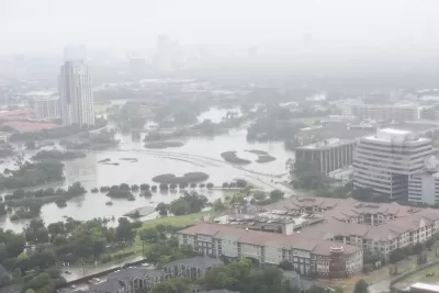
A draft statewide flood plan for Texas estimates that one in six of the state’s residents — or over 5 million people — live in a flood-prone area, reports Alejandra Martinez in The Texas Tribune.
The plan, developed by the Texas Water Development Board (TWDB), was a result of a 2019 law passed after Hurricane Harvey devastated the Houston area.
As Martinez explains, “The plan used existing flood data to create the maps that served as a baseline, but many state regions either didn't have flood maps, or used outdated maps. Local water managers filled the gaps with their knowledge and the TWDB contracted flood risk modeling data company Fathom to help.”
The TWDB recommends a variety of flood mitigation strategies, but Martinez notes that “the state doesn’t have a reliable source of revenue for flood projects unless state lawmakers approve additional funding each legislative session.”
The TWDB is also asking the state to implement an early warning system for flooding and provide technical assistance to small and rural communities. “Because money is limited for flood projects, the regional groups recommended that the state give counties the authority to collect drainage fees in unincorporated areas — currently only cities can charge such fees. The regional groups argue this would help counties self-finance flood mitigation and drainage projects outside of city limits.”
FULL STORY: Texas’ first-ever statewide flood plan estimates 5 million live in flood-prone areas


3D Modeling Aids in Predicting Hurricane Damage
Texas researchers are testing the tool in Galveston, where Hurricane Ike caused billions in damage in 2008.

New York Flood Control Plan Takes Lessons From the Dutch
The Netherlands has a long history of flood mitigation. U.S. cities, threatened by coastal flooding and erosion, are taking note.

East River Floodgates Rising in NYC
A tour of new infrastructure designed to protect the city’s East Side from catastrophic flooding.

Planetizen Federal Action Tracker
A weekly monitor of how Trump’s orders and actions are impacting planners and planning in America.

Congressman Proposes Bill to Rename DC Metro “Trump Train”
The Make Autorail Great Again Act would withhold federal funding to the system until the Washington Metropolitan Area Transit Authority (WMATA), rebrands as the Washington Metropolitan Authority for Greater Access (WMAGA).

The Simple Legislative Tool Transforming Vacant Downtowns
In California, Michigan and Georgia, an easy win is bringing dollars — and delight — back to city centers.

The States Losing Rural Delivery Rooms at an Alarming Pace
In some states, as few as 9% of rural hospitals still deliver babies. As a result, rising pre-term births, no adequate pre-term care and "harrowing" close calls are a growing reality.

The Small South Asian Republic Going all in on EVs
Thanks to one simple policy change less than five years ago, 65% of new cars in this Himalayan country are now electric.

DC Backpedals on Bike Lane Protection, Swaps Barriers for Paint
Citing aesthetic concerns, the city is removing the concrete barriers and flexposts that once separated Arizona Avenue cyclists from motor vehicles.
Urban Design for Planners 1: Software Tools
This six-course series explores essential urban design concepts using open source software and equips planners with the tools they need to participate fully in the urban design process.
Planning for Universal Design
Learn the tools for implementing Universal Design in planning regulations.
Smith Gee Studio
City of Charlotte
City of Camden Redevelopment Agency
City of Astoria
Transportation Research & Education Center (TREC) at Portland State University
US High Speed Rail Association
City of Camden Redevelopment Agency
Municipality of Princeton (NJ)