


Many communities at increased risk of flooding and wildfires will need to relocate. Here’s how local and regional governments can prepare.
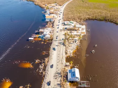
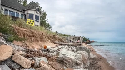
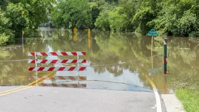
A report from the National Academies of Science, Engineering and Medicine (NASEM) urges coastal communities facing rising sea levels and other areas at risk from extreme weather to prepare for the possibility of having to relocate to adapt to the changing climate and landscape.
As Kaitlyn Levinson explains in Route Fifty, “Researchers estimate that the sea levels along the U.S. coastline could rise by up to 12 inches by 2050—an alarming progression considering that’s the same increase documented between 1920 and 2020.” Meanwhile, increasingly destructive wildfires are making some western towns unlivable. The report notes that inland communities will also need to prepare for increased migration and demand for essential services.
One way for communities to prepare is to conduct a land suitability analysis of potential relocation sites to ensure they can support the infrastructure needed. “In their relocation plans, officials should also consider amending or adopting rules on zoning, land acquisitions or open space management, the report said. For instance, policymakers can restrict future development in an area a community has moved from to prevent newer buildings from climate risks.” Governments are also creating property buyback programs to soften the impact of relocation and assist residents who would be financially burdened by the moving process.
FULL STORY: Easier said than done: Tips for community relocation amid a changing climate


Rising Above: Innovative Solutions for Waikīkī’s Sea-Level Challenges
The University of Hawaiʻi at Mānoa’s award-winning Waikīkī sea-level rise adaptation project combines science, architecture, and community input to create scalable solutions for climate resilience and coastal flood mitigation.
How US Cities Can Prepare for Climate Disasters
Resilience, encompassing infrastructure, governance, economic strength, and social cohesion, is critical for cities to mitigate rising climate risks like flooding, wildfires, and heat, ensuring long-term recovery and adaptability.
The Potential and Pitfalls of Climate Migration
As more Americans are displaced by wildfires, flooding, erosion, and other climate risks, safer regions should prepare for a wave of migration.

Planetizen Federal Action Tracker
A weekly monitor of how Trump’s orders and actions are impacting planners and planning in America.

Congressman Proposes Bill to Rename DC Metro “Trump Train”
The Make Autorail Great Again Act would withhold federal funding to the system until the Washington Metropolitan Area Transit Authority (WMATA), rebrands as the Washington Metropolitan Authority for Greater Access (WMAGA).

The Simple Legislative Tool Transforming Vacant Downtowns
In California, Michigan and Georgia, an easy win is bringing dollars — and delight — back to city centers.

The States Losing Rural Delivery Rooms at an Alarming Pace
In some states, as few as 9% of rural hospitals still deliver babies. As a result, rising pre-term births, no adequate pre-term care and "harrowing" close calls are a growing reality.

The Small South Asian Republic Going all in on EVs
Thanks to one simple policy change less than five years ago, 65% of new cars in this Himalayan country are now electric.

DC Backpedals on Bike Lane Protection, Swaps Barriers for Paint
Citing aesthetic concerns, the city is removing the concrete barriers and flexposts that once separated Arizona Avenue cyclists from motor vehicles.
Urban Design for Planners 1: Software Tools
This six-course series explores essential urban design concepts using open source software and equips planners with the tools they need to participate fully in the urban design process.
Planning for Universal Design
Learn the tools for implementing Universal Design in planning regulations.
Smith Gee Studio
City of Charlotte
City of Camden Redevelopment Agency
City of Astoria
Transportation Research & Education Center (TREC) at Portland State University
US High Speed Rail Association
City of Camden Redevelopment Agency
Municipality of Princeton (NJ)