


New guidelines for the city’s ‘streeteries’ are set to go into effect next April.
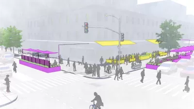
New York City has released proposed designs for on-street dining setups, known locally as ‘streeteries,’ reports Christopher Bonanos in Curbed, in anticipation of a new program that will make the al fresco patios permanent—with some caveats.
As Bonanos explains, “As before, there are two types of setups. Those on the sidewalk will face minimal change. They’re going to be allowed year-round, much as they have for decades, under umbrellas and awnings. The city is lowering the price of the permit, which suggests a stance of benign encouragement.”
The design for ‘roadway sheds,’ on the other hand, will look vastly different from the Covid-era bubble enclosures. “The new open-air-dining experience will put the emphasis on the open-air part. Apart from the big heavy barrier meant to defend against moving vehicles, the mostly waist-high structures will be rather lightly constructed and roofless but for fabric canopies (an umbrella is always an option too).”
The on-street structures will have to be dismantled between November 31 and March 31. “That will allow the streets to be plowed, should it ever snow again, and perhaps diminish the number of winter-storm blow-downs.”
FULL STORY: The 2024 Streetery Is Taking Shape

New York City Legalizes Outdoor Dining
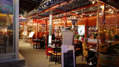
Some restaurant owners worry the new requirements will make it too expensive to maintain outdoor dining structures.
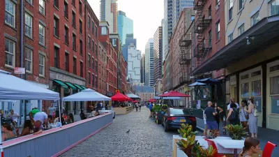
Open Streets and Outdoor Dining Are Best for Business, Report Says
Most business owners believe that they'd be out of business without on-street parking near their front door. The experience of New York City during the pandemic proves otherwise.
Who Should Manage New York’s Outdoor Dining Program?
A proposal to shift responsibility away from the Department of Transportation has met staunch resistance from industry groups and advocates of the program.

Planetizen Federal Action Tracker
A weekly monitor of how Trump’s orders and actions are impacting planners and planning in America.

Congressman Proposes Bill to Rename DC Metro “Trump Train”
The Make Autorail Great Again Act would withhold federal funding to the system until the Washington Metropolitan Area Transit Authority (WMATA), rebrands as the Washington Metropolitan Authority for Greater Access (WMAGA).

DARTSpace Platform Streamlines Dallas TOD Application Process
The Dallas transit agency hopes a shorter permitting timeline will boost transit-oriented development around rail stations.

Maryland Plans Quick-Build Complete Streets Projects
The state will use low-cost interventions to improve road safety in five Maryland counties.

Downtown Los Angeles Gears Up for Growth
A new report highlights Downtown L.A.’s ongoing revival through major housing projects, adaptive reuse, hospitality growth, and preparations for global events in the years ahead.

Supreme Court Landlord Appeal Case Could Overturn Tenant Protections
A legal case claiming that COVID-era eviction moratoriums were unconstitutional could spell trouble for tenant protections.
Urban Design for Planners 1: Software Tools
This six-course series explores essential urban design concepts using open source software and equips planners with the tools they need to participate fully in the urban design process.
Planning for Universal Design
Learn the tools for implementing Universal Design in planning regulations.
Municipality of Princeton
Roanoke Valley-Alleghany Regional Commission
City of Mt Shasta
City of Camden Redevelopment Agency
City of Astoria
Transportation Research & Education Center (TREC) at Portland State University
US High Speed Rail Association
City of Camden Redevelopment Agency
Municipality of Princeton (NJ)