


The agency released a set of plans showing proposed station infrastructure as it works to expand BRT to a larger area around Atlanta.
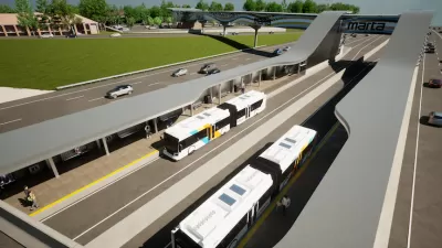
The Metropolitan Atlanta Rapid Transit Authority (MARTA) took another step in its effort to expand bus rapid transit to more cities, which includes BRT linking downtown Atlanta to Summerhill and along the Clifton Corridor, on Campbellton Road, in Clayton County. As Josh Green explains, “MARTA officials have released a bevy of project renderings to Urbanize Atlanta that show potential plans for a BRT station at a key Ga. Highway 400 crossroads, Holcomb Bridge Road in Roswell.”
“The Roswell station could be the southernmost stop on MARTA’s proposed 13-mile BRT route along Ga. Highway 400—and the first stop north of the transit agency’s current North Springs station, where MARTA rail ends.” The renderings show dedicated bus lanes, a park-and-ride lot, and bike and pedestrian infrastructure, as well as connectivity to Holcomb Bridge Road.
While the exact sites of future stations are yet to be determined, Green writes that “The BRT expansion would be installed during the Georgia Department of Transportation’s new express lane construction on the highway in coming years.”
See the source article for a gallery of renderings and more details about MARTA’s BRT plans.
FULL STORY: 26 renderings: MARTA's vision for rapid bus service on Ga. 400

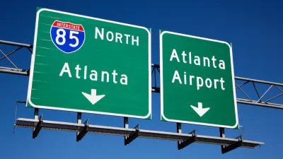
MARTA To Add BRT Connection to Airport
A new rapid bus line in Atlanta will link residents to one of the nation’s busiest airports.
What Is ‘Arterial Rapid Transit?’
Atlanta is planning to build ‘BRT lite,’ a version of bus service that offers signal priority and fewer stops but keeps buses in mixed-traffic lanes.
Atlanta Gaining Two New ‘Arterial Rapid Transit’ Lines
MARTA will begin construction on two new bus lines this year, which will share lanes with other vehicles but use other tools to speed up service.

Maui's Vacation Rental Debate Turns Ugly
Verbal attacks, misinformation campaigns and fistfights plague a high-stakes debate to convert thousands of vacation rentals into long-term housing.

Planetizen Federal Action Tracker
A weekly monitor of how Trump’s orders and actions are impacting planners and planning in America.

In Urban Planning, AI Prompting Could be the New Design Thinking
Creativity has long been key to great urban design. What if we see AI as our new creative partner?

King County Supportive Housing Program Offers Hope for Unhoused Residents
The county is taking a ‘Housing First’ approach that prioritizes getting people into housing, then offering wraparound supportive services.

Researchers Use AI to Get Clearer Picture of US Housing
Analysts are using artificial intelligence to supercharge their research by allowing them to comb through data faster. Though these AI tools can be error prone, they save time and housing researchers are optimistic about the future.

Making Shared Micromobility More Inclusive
Cities and shared mobility system operators can do more to include people with disabilities in planning and operations, per a new report.
Urban Design for Planners 1: Software Tools
This six-course series explores essential urban design concepts using open source software and equips planners with the tools they need to participate fully in the urban design process.
Planning for Universal Design
Learn the tools for implementing Universal Design in planning regulations.
planning NEXT
Appalachian Highlands Housing Partners
Mpact (founded as Rail~Volution)
City of Camden Redevelopment Agency
City of Astoria
City of Portland
City of Laramie