


The cities that are making their pandemic-era car-free experiments permanent.
While some cities are reverting their ‘open streets’ to car-oriented spaces, others are keeping the car-free spaces created during the pandemic. An article by Linda Poon, Feargus O'Sullivan, and Amy Yee in Bloomberg CityLab highlights the places where street transformations are becoming part of the permanent fabric of the city.
The list includes San Francisco’s John F. Kennedy Drive, a mile of which winds through Golden Gate Park. After the city banned cars on this stretch in 2020, local groups mounted an intense opposition campaign. “It has since turned into a full-out pedestrian promenade, with vibrant street murals and eye-popping art installations, including a trio of seven-foot-tall dachshund head sculptures from the city’s defunct fast-food icon Doggie Diner, planted right in the middle of the street.” Ultimately, the city decided to keep the road car-free.
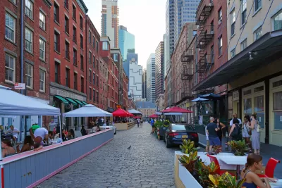
Another success story is 34th Avenue in Jackson Heights, Queens, which became a vibrant pedestrian hub as part of the city’s Open Streets initiative. While there is some local opposition, the street has so far remained car-free.
The article also describes projects in Stockholm, Paris, Milan, Bogotá, and Quito, where a 1-mile segment of Viracocha Street was made safer for pedestrians and cyclists with extended sidewalks, new crosswalks, narrowed traffic lanes, and a street mural.
FULL STORY: The Cities Keeping Their Car-Free Spaces

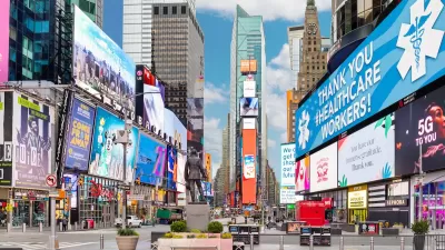
NYC Officials Announce Broadway Pedestrianization Project
Two blocks of the marquee street will become mostly car-free public spaces.
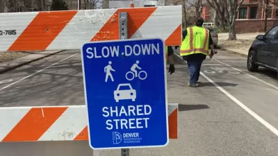
Denver Plans to Make Some Open Streets Permanent
The city is moving to institutionalize segments of streets that were successfully pedestrianized during the pandemic.
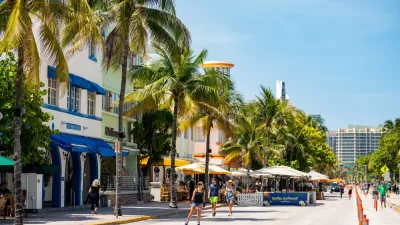
Miami Beach to Reopen Ocean Drive to Cars
The famous cruising strip was off-limits to cars during the pandemic. Now, the city is letting vehicles return with some pedestrian-oriented compromises.

Montreal Mall to Become 6,000 Housing Units
Place Versailles will be transformed into a mixed-use complex over the next 25 years.

Planetizen Federal Action Tracker
A weekly monitor of how Trump’s orders and actions are impacting planners and planning in America.

DARTSpace Platform Streamlines Dallas TOD Application Process
The Dallas transit agency hopes a shorter permitting timeline will boost transit-oriented development around rail stations.

Study: 4% of Truckers Lack a Valid Commercial License
Over 56% of inspected trucks had other violations.

Chicago Judge Orders Thousands of Accessible Ped Signals
Only 3% of the city's crossing signals are currently accessible to blind pedestrians.

Philadelphia Swaps Car Lanes for Bikeways in Unanimous Vote
The project will transform one of the handful of streets responsible for 80% of the city’s major crashes.
Urban Design for Planners 1: Software Tools
This six-course series explores essential urban design concepts using open source software and equips planners with the tools they need to participate fully in the urban design process.
Planning for Universal Design
Learn the tools for implementing Universal Design in planning regulations.
City of Mt Shasta
City of Camden Redevelopment Agency
City of Astoria
Transportation Research & Education Center (TREC) at Portland State University
US High Speed Rail Association
City of Camden Redevelopment Agency
Municipality of Princeton (NJ)