


A consumption-based analysis illustrates the differences in average household emissions across census tracts.
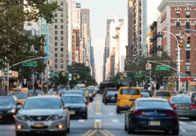
A set of maps based on University of California, Berkeley research highlights the climate impact of households in different neighborhoods, as outlined in a New York Times article by Nadja Popovich, Mira Rojanasakul, and Brad Plumer.
The data indicates that, while households in central cities tend to have lower carbon footprints thanks to access to transit and smaller homes, wealthier neighborhoods, even in dense, transit-rich cities like New York, have larger footprints than their close neighbors. “The researchers used a model, a simplified mathematical representation of the real world, to estimate the average household’s emissions in each neighborhood based on electricity use, car ownership, income levels, consumption patterns and more.”
The consumption-based analysis traces emissions to the households responsible for them rather than measuring them at the point of production. “The original idea behind the research, which began more than a decade ago, was to connect climate change with daily life, to help people understand how their choices contribute to a global problem,” according to Chris Jones, director of the CoolClimate Network at Berkeley, who developed the methodology.
The article points out that consumption results from a series of decisions, some made at the individual level, others, such as housing and transportation policy, at systemic levels. Now, Jones hopes cities can use the data to identify the most climate-friendly policies “by, for example, encouraging developers to build more housing in neighborhoods where people don’t need cars to get around or helping households in suburbs more quickly adopt cleaner electric vehicles.”
FULL STORY: The Climate Impact of Your Neighborhood, Mapped


Which US Rail Agencies Are Buying Zero-Emissions Trains?
U.S. rail agencies are slowly making the shift to zero-emissions trains, which can travel longer distances without refueling and reduce air pollution.

How Housing Density Could Help Austin Reach Climate Goals
With housing and transportation as the two biggest sources of carbon emissions, a new report shows how boosting density near transit would accelerate emissions reductions.

The Path to Hyperdensity
The federal government has an opportunity to make a generational investment in the country's infrastructure that could fundamentally shift the way we live and move around cities.

Planetizen Federal Action Tracker
A weekly monitor of how Trump’s orders and actions are impacting planners and planning in America.

Chicago’s Ghost Rails
Just beneath the surface of the modern city lie the remnants of its expansive early 20th-century streetcar system.

San Antonio and Austin are Fusing Into one Massive Megaregion
The region spanning the two central Texas cities is growing fast, posing challenges for local infrastructure and water supplies.

Since Zion's Shuttles Went Electric “The Smog is Gone”
Visitors to Zion National Park can enjoy the canyon via the nation’s first fully electric park shuttle system.

Trump Distributing DOT Safety Funds at 1/10 Rate of Biden
Funds for Safe Streets and other transportation safety and equity programs are being held up by administrative reviews and conflicts with the Trump administration’s priorities.

German Cities Subsidize Taxis for Women Amid Wave of Violence
Free or low-cost taxi rides can help women navigate cities more safely, but critics say the programs don't address the root causes of violence against women.
Urban Design for Planners 1: Software Tools
This six-course series explores essential urban design concepts using open source software and equips planners with the tools they need to participate fully in the urban design process.
Planning for Universal Design
Learn the tools for implementing Universal Design in planning regulations.
planning NEXT
Appalachian Highlands Housing Partners
Mpact (founded as Rail~Volution)
City of Camden Redevelopment Agency
City of Astoria
City of Portland
City of Laramie