


A new book outlines the benefits of public investment at the regional scale.
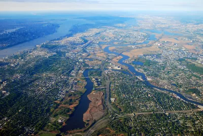
A new book from the Lincoln Institute by Robert D. Yaro, Ming Zhang, and Frederick R. Steiner examines the role of 'megaregions' in shaping the future of U.S. policy and planning. As Will Jason writes, "Megaregions and America’s Future explains the concept of megaregions, provides updated economic, demographic, and environmental data, draws lessons from Europe and Asia, and shows how megaregions are an essential framework for governing the world’s largest economy."
Geared to urban and regional planners and policy analysts, staff and decision makers in transportation, environmental protection, and development agencies, faculty and students in related fields, as well as business leaders, Megaregions and America’s Future includes a case study of the Northeast—the nation’s oldest megaregion and the source of the concept—but delves deeply into every megaregion, from the Great Lakes to the Gulf Coast to Southern California.
The authors argue that a regional approach is more appropriate for large-scale issues such as sea level rise or high-speed rail that require action across a broad geographic area. According to the book, megaregions are "the perfect geographic unit for channeling federal investment and managing large systems such as interstate rail, multistate natural resource systems, climate mitigation or adaptation, and major economic development initiatives."
FULL STORY: New Book on Megaregions Provides a Framework for Large-Scale Public Investment


Pressing Pause on Development in the Shadow of Austin's Growth
The Dripping Springs City Council points to inadequate wastewater infrastructure and the need to update its comprehensive plan as reasons for the city's development moratorium.

Reforming Local Development Regulations for Sustainable Megaregions
Managing development at the scale of megaregions is possible. An excerpt from the recently published book, "Designing for the Megaregion: Meeting Urban Challenges at a New Scale," written by Jonathan Barnett, explains how.
Why the Infrastructure Bank is Right On
Columnist Neal Peirce throws his weight behind the Obama Infrastructure Bank proposal.

Planetizen Federal Action Tracker
A weekly monitor of how Trump’s orders and actions are impacting planners and planning in America.

Congressman Proposes Bill to Rename DC Metro “Trump Train”
The Make Autorail Great Again Act would withhold federal funding to the system until the Washington Metropolitan Area Transit Authority (WMATA), rebrands as the Washington Metropolitan Authority for Greater Access (WMAGA).

DARTSpace Platform Streamlines Dallas TOD Application Process
The Dallas transit agency hopes a shorter permitting timeline will boost transit-oriented development around rail stations.

Renters Now Outnumber Homeowners in Over 200 US Suburbs
High housing costs in city centers and the new-found flexibility offered by remote work are pushing more renters to suburban areas.

The Tiny, Adorable $7,000 Car Turning Japan Onto EVs
The single seat Mibot charges from a regular plug as quickly as an iPad, and is about half the price of an average EV.

Supreme Court Ruling in Pipeline Case Guts Federal Environmental Law
The decision limits the scope of a federal law that mandates extensive environmental impact reviews of energy, infrastructure, and transportation projects.
Urban Design for Planners 1: Software Tools
This six-course series explores essential urban design concepts using open source software and equips planners with the tools they need to participate fully in the urban design process.
Planning for Universal Design
Learn the tools for implementing Universal Design in planning regulations.
Municipality of Princeton
Roanoke Valley-Alleghany Regional Commission
City of Mt Shasta
City of Camden Redevelopment Agency
City of Astoria
Transportation Research & Education Center (TREC) at Portland State University
US High Speed Rail Association
City of Camden Redevelopment Agency
Municipality of Princeton (NJ)